Map of DR Congo
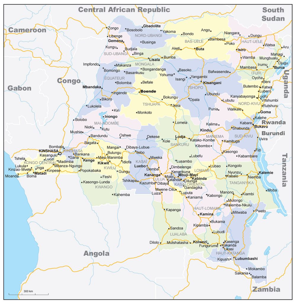
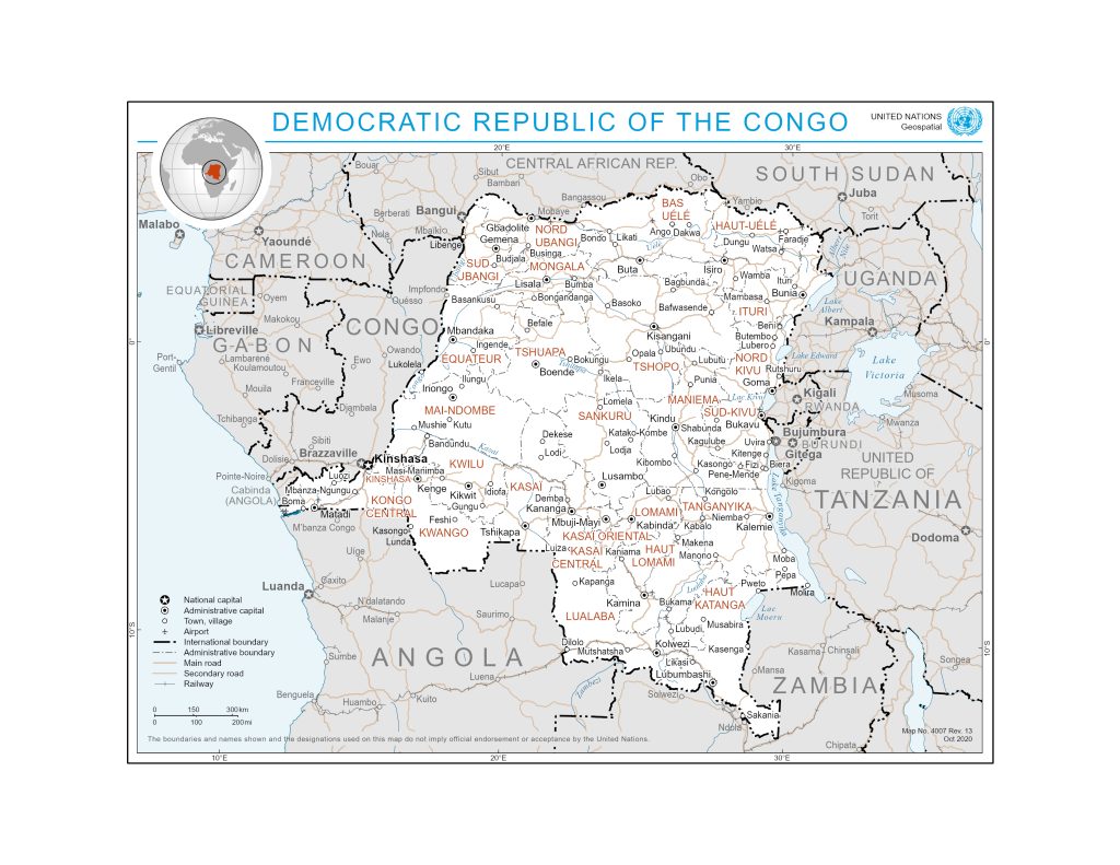
Democratic Republic of the Congo map online
General description of the Democratic Republic of the Congo (DRC)
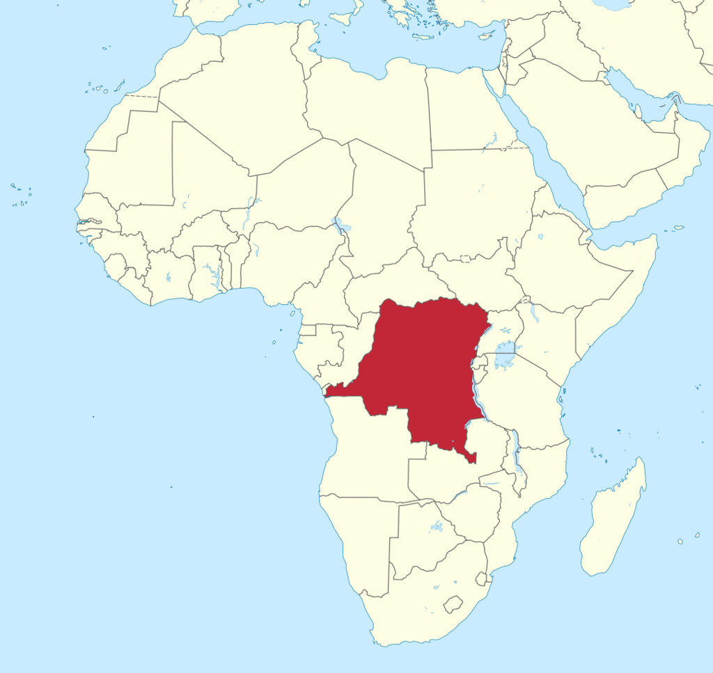
 The Democratic Republic of the Congo is located slightly west of the center of Africa.
From 1886 to 1962, the Congo belonged to Belgium as a colonial possession.
Since 2022, it has been part of the East African Community.
The state occupies the eleventh place in the world in terms of territory, the area of the Congo is 2,345,409 kilometers. The country is home to about 108,407,721 people, making it the fourth most populous country after Nigeria, Ethiopia and Egypt. The locals speak French.
The DRC is one of the largest countries in Africa, ranking second on the mainland after Algeria.
The capital of Congo is Kinshasa. It is the largest French-speaking city in the world, located on the south bank of the Congo River. In terms of territory, it is second only to Cairo and Lagos. Kinshasa has about 12,000,000 inhabitants.
The physical map of the DRC shows the African Rift Valley in the east of the country and access to the sea in the west. The country has one of the shortest coastlines in the world, its length is only 37 kilometers.
East African rift systems run along the length of the country’s eastern border. Deep depressions are framed by the Rwenzori mountain range, which stretches for 120 kilometers in length and has a width of about 50 kilometers. The mountain formation consists of six ranges, the highest of which is called Stanley Peak and has a height of 5109 meters. Deep lakes are located around the depressions: Kivu, Albert, Tanganyika, Mweru, Eduard. Not far from Lake Kivuna is the Virunga volcanic massif , which consists of at least a hundred volcanoes. The highest of them is the Karisimbi Ridge, its height is 4507 meters. Volcanoes Nyamuragira and Nyiragongo are active.
The river of the same name flows in the Congo. It is the second largest in Central Africa.
Climate DR Congo
The climate in the Congo, depending on the region of the country, can be tropical wet or dry, and the air temperature and humidity level can reach high levels. The average annual temperature is around 25°C. The southern highlands are characterized by cool and dry winters and warm, humid summers. In the mountains it is somewhat colder, as you rise, the humidity increases. Some slopes are constantly shrouded in fog.
Location on the world map above the equator affects seasonal precipitation. So, when the dry season is established in the northern part of the country, long rains begin in the south. On average, about two thousand millimeters of precipitation falls in the Congo.
Location of Congo on the world map
 The Democratic Republic of the Congo is a Central African country located on the right bank of the Congo River south of the Sahara Desert. The DRC is a plain and is located on both sides of the equator.
On the world map next to the Democratic Republic of the Congo are located: the Central African Republic, the Republic of the Congo, Tanzania, Burundi, Uganda, South Sudan, Zambia, Angola.
The surface of the state has a slope from south to north, which begins at the border with Angola at an altitude of 1000 meters and drops to 500 meters at the pool.
The vegetation cover on the territory of the southern highlands is more diverse than on the territory of the northern highlands. Depending on the area, the Congo can be dominated by both forests and savanna grasses.
Relief
The DRC is a wide, flat area overgrown with forests, ridges in the east, fields in the north, and savannahs in the southwest.
Highlands separate the country from the Atlantic Ocean. From the side of the ocean, lowlands stretch for 40-50 kilometers, then there are small Mayombe mountain ranges , whose height does not exceed 500 meters. A little further to the east is the Niari-Nyanga depression , which is 200 meters high. The middle of the depression consists of a limestone plane, where karst phenomena lead to the formation of voids in the ground. The bottom lies at an altitude of 400 meters above sea level and is covered with swamps. The north and east of the basin is represented by the Shayu Ranges, whose height is more than 700 meters, the southeast – by the Cataract Plain. These areas are the highest and most difficult to pass part of the country.
The central part of the DRC is the Bateke Plain, on which the highest point of the country is located – Mount Leketi, whose height is 1040 meters.
The northeast of the state is heavily swamped and is often flooded by the waters of the Congo River.
The southeast of the state on the map of the Congo is indicated by the Mitumba mountain ranges, and the sandy plains of Manica and Kundigung.
Water resources: seas, rivers and lakes
The state’s longest and deepest river is the Congo River, which provides the country with navigable waterways. The length of the river is about ten kilometers, only the South American Amazon is larger than it. The Congo is fed by rivers and streams on both sides of the equator, and the alternating rainy and dry seasons ensure a regular supply of water to the main canal.
The main part of the DRC is served by the Congo River and its many tributaries, evenly distributed throughout the country. Exceptions are: the Mayombe area, where the Chiloango River flows; the area on the eastern border adjacent to lakes Edward and Albert; and part of the southeastern region of the country, where the Zambezi river basin is located.
The physical map of the Congo shows that most of the lakes are part of the Congo Basin. Lakes Mai-Ndombe and Tumba are located in the western part of the country. Once they were part of a huge drainless lake that occupied the entire basin. But the Congo River broke through the edges of the basin and drained the lake. However, Mai-Ndombe remains a fairly large body of water, the length of which is 130 kilometers. Tumba represents a system of flooded valleys with an area of about 500 square kilometers.
Lake Mweru is located on the border with Zambia. This large lake with fresh water stretches for 118 kilometers. Not far from the border with Rwanda is located lake Kivuwhose area is 2700 square kilometers. Due to the saturation of the lower layers of water with methane and carbon dioxide, the lake is considered the most dangerous in the world. The reservoir has a drain that flows into Lake Taganika .
To the north are Lakes Edward and Albert, whose waters flow into the Nile basin.
The largest cities on the map of DR Congo
 The map of the Democratic Republic of the Congo shows 25 cities with about 86,791,000 inhabitants. The largest of them is the main city of the state – Kinshasa.
Kinshasa
The capital is located on the banks of the Congo River. It has been the main city of the state since 1960. About 10,077,000 inhabitants live in the settlement, which brings the city to the first place in terms of population in the state. Most of the people speak French.
The west of the province is densely populated, while the rest of the city is rural and sparsely populated.
Kinshasa has a river port, a railway station and an international airport.
Lubumbashi
Lubumbashi is the economic center of the Upper Katanga region . The city is the second largest in the DRC. The population is about 1630 200 people. The main part of the population is employed in the mining and smelting of copper, as well as in the production of textiles and in the chemical industry.
The city has an international airport and a railway junction.
Mbuji Mayi
Mbuju-Mayi is the economic center of the Eastern Kasai region , located on the banks of the Sankuru . It is the third largest city in the Congo. It is an important diamond mining center. The food industry is also developed in the city. The population of the administrative center is about 1,560,000 people.
Bukavu
Bukavu is located in the eastern part of the country on the shores of Lake Kivu and is the economic center of South Kivu. The city is close to the border with Rwanda.
Bukavu has about 242,000 inhabitants.
The main Catholic church of the country is located in the city – Notre Dame de la Paix Cathedral , the Catholic University and the residence of the archbishop.
Other cities in DRC:
- Kananga is the administrative center of the Lulua district. About 1,061,000 inhabitants live in the settlement. The city is of great economic and political importance.
- Kisangani – located in the northeast of the DRC, is the economic center of the Chopo region . About 936,000 people live in the city. Kisangani has a developed textile, chemical, food industry and woodworking.
- Goma is a city located on the border with the Republic of Rwanda. It is the economic center of the North Kivu region. According to the demographic map, the city has at least 560,000 inhabitants.
- Kolwezi is the economic center of Lualaba province. About 454,000 people live in the settlement. Large deposits of natural resources are located in the Kolwezi region: uranium, cobalt, copper, limestone.
- Matadi – located on the coast of the Congo and is the main seaport of the DRC. The settlement is located on a steep hillside. About 246 people live in the city. Main cargo flow of the state goes through Matadi. They transport mainly wood and coffee beans.
 The Guide Maps