Massachusetts map, USA
General map of Massachusetts live
Massachusetts is a northeastern state in the New England region. The name came from the name of a native Massachusett tribe.
-

- Large Detailed Map of Massachusetts With Cities and Towns

-

- Massachusetts Road Map

-

- Road map of Massachusetts with cities

History of Massachusetts
The first English colonialists landed in this area at the very beginning of the 17th century. Their contacts with the indigenous people turned out to be disastrous for the latter: the Indians died en masse from unusual European diseases.
In 1620, persecuted Puritans, who had left England, landed on the shore of Cape Cod . They founded the first European settlement in Massachusetts , called the Plymouth Colony. In the development of a new place, the surviving Indians helped the settlers. The unexpectedly rich first harvest was celebrated by Puritans and Indians as a holiday – Thanksgiving Day. In subsequent years, new settlements were laid, and the future city of Boston appeared on the maps.
In 1692, a number of colonies and individual provinces merged into an English macro -colony Massachusetts Bay , where intolerant Puritans continued to set the tone. In the same year, they organized a “witch hunt” in the city of Salem , in which 19 people became victims.
In the next century, tensions grew between the colonies and the mother country. In Massachusetts , it became the Boston Massacre, then the Boston Tea Party. Among the 13 colonies , Massachusetts revolted against Great Britain. In 1788, he approved the US constitution, and appeared on the US map as the sixth state of the young state. It still retains the informal name “Puritan State”.
In the 19th century Massachusetts became known as the center of American shipbuilding and navigation. In the 20th century, the state also took a leading position in the fields of biotechnology, higher education, finance and engineering, and not only in the United States.
Location of the state of Massachusetts on the US map
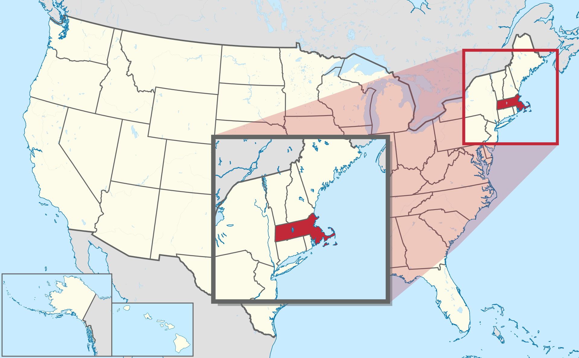
Location map of Massachusetts in the US.
Massachusetts with an area of over 27 thousand km2 occupies the northeastern part of the United States. Its eastern border is the coast of the Atlantic Ocean. Several large bays are located on the coast of the state, which is why Massachusetts is informally called the “State of the Bays”. As you can see on the map of Massachusetts , all other borders are land:
- in the west – with the state of New York;
- in the north – with Vermont and New Hampshire;
- in the south – with Connecticut and Rhode Island.
Relief and reservoirs
Most of Massachusetts occupies the eastern coastal plain, which is home to the main urban population of the state. To the west lies rolling countryside. In the extreme west of the state are the Taconic mountain range and the Berkshire Hills and Greylock mountains , with a peak of 1064 meters. Deciduous forests cover over 60% of the state.
The landscape of the state was shaped by ancient glaciation, traces of which are numerous. Lakes and numerous rivers and streams are scattered throughout the territory.
Climate
Most of Massachusetts is dominated by a humid continental climate, characterized by cold winters and warm summers. A milder oceanic climate prevails in some coastal areas. Proximity to the Atlantic Ocean causes frequent hurricanes and storms.
Major cities of Massachusetts on the map
Boston
One of the largest cities in the US, Boston is the capital of Massachusetts . It is located on the coast of Boston Bay in Massachusetts Bay . Boston is a relatively compact city with an area of over 125 km 2 , about half of which is water. Most of Boston is built on fill land from the nearby hills, hiding the original swamps.
Worcester
The main city of the central part of Massachusetts is Worcester . It was built on a dozen nearby hills. Beneath the center of Worcester , mostly underground, is the Blackstone River . Within the city limits are two large lakes – Indian and Quinsigamond, as well as many ponds.
Springfield
The county seat of Hampden Springfield is known as the birthplace of basketball. The city is located in the valley of the Connecticut River, near the confluence of two tributaries into it. In the eastern part of Springfield , the terrain becomes hilly. The city is home to one of the largest municipal forest parks in the United States .
Cambridge
The famous Harvard University and the Institute of Technology make Cambridge the student and scientific center of the state. The city is located on the north bank of the Charles River , which separates it from Boston. Cambridge borders on Boston, Somerville , Arlington , Belmont and Watertown.
Lowell
The town of Lowell, Middlesex County, is located along the rapids of the Merrimack River near its confluence with another river, the Concord. In the relief of the city, glacial deposits are traced – drumlins (small hills).
| № | Locality | State | Coordinates | Stations |
|---|---|---|---|---|
| 1 | Yarmouth Port | Massachusetts | - | 0 |
| 2 | Wrentham | Massachusetts | - | 0 |
| 3 | Woods Hole | Massachusetts | - | 0 |
| 4 | Winthrop Beach | Massachusetts | - | 0 |
| 5 | Westwood | Massachusetts | - | 0 |
| 6 | Westport Point | Massachusetts | - | 0 |
| 7 | Westfield | Massachusetts | - | 0 |
| 8 | Westborough | Massachusetts | - | 0 |
| 9 | West Wrentham | Massachusetts | - | 0 |
| 10 | West Hyannisport | Massachusetts | - | 0 |
| 11 | Wellfleet | Massachusetts | - | 0 |
| 12 | Wellesley | Massachusetts | - | 0 |
| 13 | Waltham | Massachusetts | - | 0 |
| 14 | Templeton | Massachusetts | - | 0 |
| 15 | Taunton | Massachusetts | - | 0 |
| 16 | Swift River | Massachusetts | - | 0 |
| 17 | Sudbury | Massachusetts | - | 0 |
| 18 | Sturbridge | Massachusetts | - | 0 |
| 19 | Stoughton | Massachusetts | - | 0 |
| 20 | Stockbridge | Massachusetts | - | 0 |
| 21 | Springfield | Massachusetts | - | 0 |
| 22 | Southwick | Massachusetts | - | 0 |
| 23 | Southampton | Massachusetts | - | 0 |
| 24 | South Weymouth | Massachusetts | - | 0 |
| 25 | South Middleboro | Massachusetts | - | 0 |
| 26 | Seekonk | Massachusetts | - | 0 |
| 27 | Scituate | Massachusetts | - | 0 |
| 28 | Sandwich | Massachusetts | - | 0 |
| 29 | Rockland | Massachusetts | - | 0 |
| 30 | Roaring Brook Camp | Massachusetts | - | 0 |
| 31 | Revere | Massachusetts | - | 0 |
| 32 | Rehoboth | Massachusetts | - | 0 |
| 33 | Raynham | Massachusetts | - | 0 |
| 34 | Quincy | Massachusetts | - | 0 |
| 35 | Provincetown | Massachusetts | - | 0 |
| 36 | Popponesset Island | Massachusetts | - | 0 |
| 37 | Pocasset | Massachusetts | - | 0 |
| 38 | Pittsfield | Massachusetts | - | 0 |
| 39 | Pembroke | Massachusetts | - | 0 |
| 40 | Patuisset | Massachusetts | - | 0 |