Missouri map, USA
General map of Missouri live
- Missouri highway map
- Large detailed map of Missouri with cities and town
- Road map of Missouri with cities
History of Missouri
Missouri is the 24th state in the United States of America. About a thousand years ago, Indian settlements were located on the territory of Missouri, but when French explorers set foot on these lands in the second half of the 17th century, they were already uninhabited. The pioneers declared the region the property of France, then it appeared on the maps under the name of Louisiana.
As a result of the French and Indian War, the Missouri territory came under the control of the King of Spain. In 1800, France again became the owner of these lands, but only in order to sell them to the United States 3 years later.
Missouri became part of the United States in 1821 as a result of the decision to admit to the United States one slave state, which turned out to be Missouri, and one free state (Maine).
During the Civil War, Missouri turned out to be a border state and one of the main places of armed clashes. Its territory was divided into 2 parts and had 2 governments. About 100,000 Missouri sided with the northerners, and 40,000 sided with the South.
After the War of the North and South, Missouri served as an important transit state.
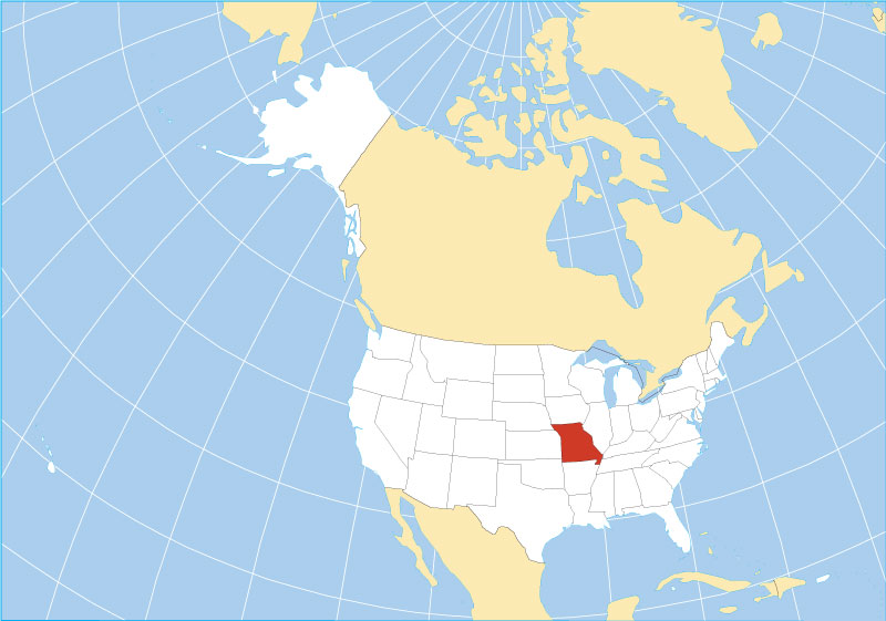
Location of the state of Missouri on the US map
The state of Missouri on the map is located in the geographic region of the Midwest. Territory area: 180.7 thousand km 2 . Includes 114 counties and the city of St. Louis, whose inhabitants voted for its independence in 1876.
The state capital is Jefferson City. On the map of Missouri, it lies in the central region, in the northern part of the Ozark region.
Missouri is surrounded by 8 other Federation states and has the following boundaries:
- land border in the south (Arkansas);
- land border in the north (Iowa);
- the river border along the Mississippi in the east (Illinois, Kentucky, Tennessee);
- the river border along the Missouri (Kansas, Oklahoma) and the land border (Nebraska) in the west. The Missouri River cuts horizontally through the entire state and divides it in half.
Geography of the state
Missouri can be divided into 3 geographic regions:
- Northern Plains .
They occupy about 1/3 of the territory, are located north of the Missouri River and in the southwest of the state. They are a hilly area with many tributaries and streams.
- Plateau of the Ozarks.
It is located in the southern part of Missouri and looks like a low dome with faults and dominant mountain ranges up to 540 meters high. It occupies a little less than 2/3 of the state. This tree-covered highland is particularly rich in forest resources and minerals.
- Alluvial plain of the Mississippi . The smallest region in terms of area (7.8 thousand km 2 ). This area has the flattest terrain and is swampy in the lowest places.
There are 2 major rivers in the state: the Mississippi and its tributary the Missouri. The largest lake of the Ozarks is located in southern Missouri, surrounded by the mountains of Saint-Francois.
Climate
A large area of the state has a humid continental type of climate. Winters are moderately dry and cool, and summers are hot with a lot of precipitation. Closer to the south, a humid subtropical climate prevails.
Missouri is in an area called “Tornado Alley” by meteorologists, where cold Arctic air meets hot air from the Gulf of Mexico. About 50 days a year there can be extreme weather with severe thunderstorms and tornadoes.
Major cities of Missouri on the map
Kansas City
The largest city in Missouri, both in terms of area (818.4 km2 ) and population (508.1 thousand people). On the map of the state, it is located on the banks of the Missouri River and borders the state of Kansas in the west. The relief in the city is flat (up to 100 m).
St. Louis
Located on the border with the state of Illinois in the east of the state. The territory of the city is a gently sloping prairie with almost flat valleys and low hills. The Mississippi River forms the city’s eastern boundary.
Springfield
Located in southwestern Missouri in the Ozarks on the Springfield Plateau. Many lakes, tributaries and streams flow near the city, the plateau is covered with pastures and forests.
Independence
The city is located near the western border of Missouri on the banks of the river of the same name with the state. The relief of the city is also flat.
Colombia
Lies in the north of the state, near the cities of Jefferson City and St. Louis, in the regions of the Northern Plains and the Ozark Plateau. It has a slope: in the north-east of the city there is the highest point, in the south-west – the lowest.
| № | Locality | State | Coordinates | Stations |
|---|---|---|---|---|
| 1 | West Plains | Missouri | - | 0 |
| 2 | Saint Joseph | Missouri | - | 0 |
| 3 | Ruskin Heights | Missouri | - | 0 |
| 4 | Osage Beach | Missouri | - | 0 |
| 5 | Lees Summit | Missouri | - | 0 |
| 6 | Lake Ozark | Missouri | - | 0 |
| 7 | Independence | Missouri | - | 0 |
| 8 | High Ridge | Missouri | - | 0 |
| 9 | Hazelwood | Missouri | - | 0 |
| 10 | Hannibal | Missouri | - | 0 |
| 11 | Grandview | Missouri | - | 0 |
| 12 | Lake Ozark | Missouri | - | 0 |
| 13 | Osage Beach | Missouri | - | 0 |
| 14 | Excelsior Springs | Missouri | - | 0 |
| 15 | Byrnes Mill | Missouri | - | 0 |
| 16 | Bridgeton | Missouri | - | 0 |
| 17 | Bonne Terre | Missouri | - | 0 |
| 18 | Birch Tree | Missouri | - | 0 |
| 19 | Bella Vista | Missouri | - | 0 |
| 20 | Arnold | Missouri | - | 0 |
| 21 | Kansas City | Missouri | - | 0 |
 The Guide Maps


