Map of Indonesia
Republic of Indonesia map online
-

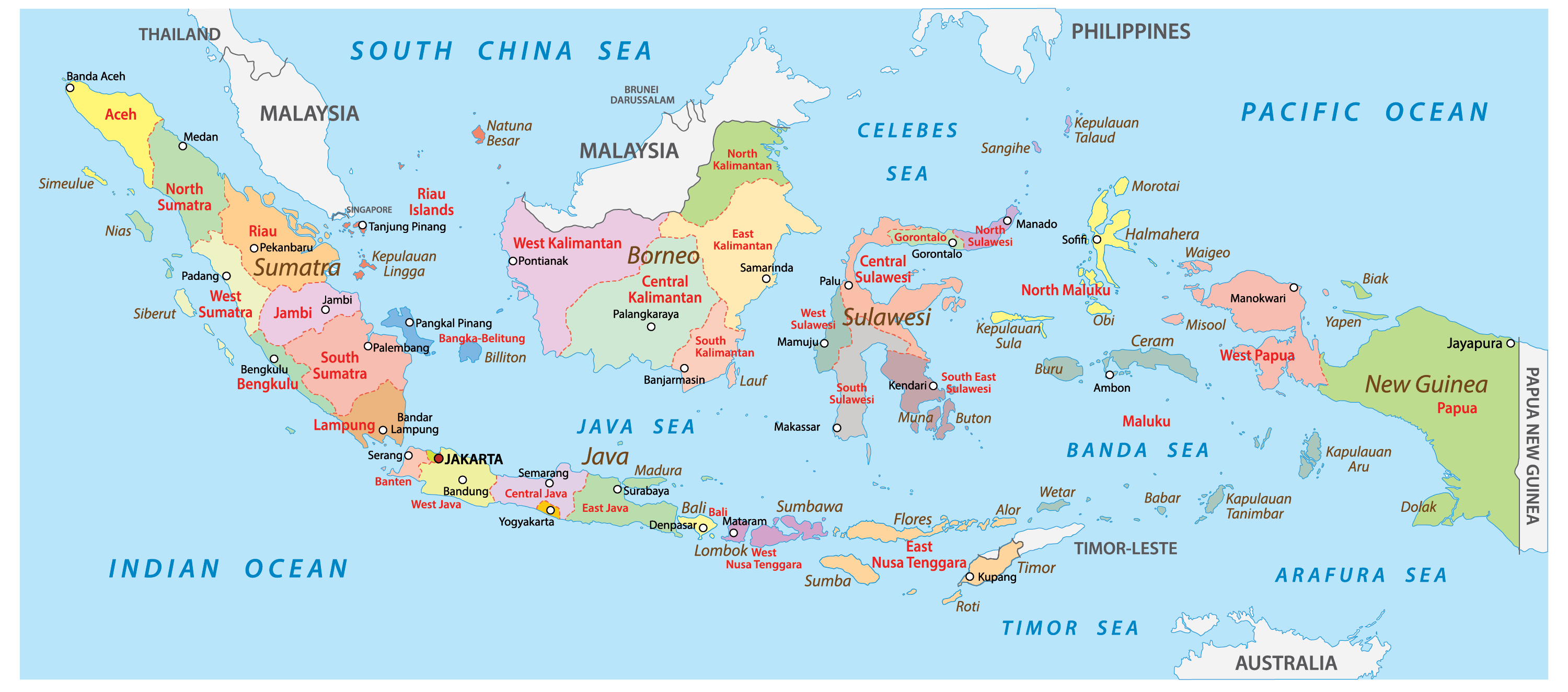
- Administrative-territorial structure Republic of Indonesia


-

- Physical map of Indonesia with relief and rivers

-

- Republic of Indonesia and Philippines


General description of the Republic of Indonesia
 The Republic of Indonesia is one of the largest sovereign states of Southeast Asia (SEA). It is bordered by the Pacific Ocean in the southwest and the Indian Ocean in the northeast.
There are no sovereign state formations within the Republic. Indonesia is a unitary state with a significant role in the administration of the president.
The Republic is the largest state in the world, located on several islands. The area of the territory is 1.9 million km2 . This is the first state in Southeast Asia by area and 14th in the world. On the map of Indonesia, there are officially 17804 islands.
Etymology of the modern name of the republic
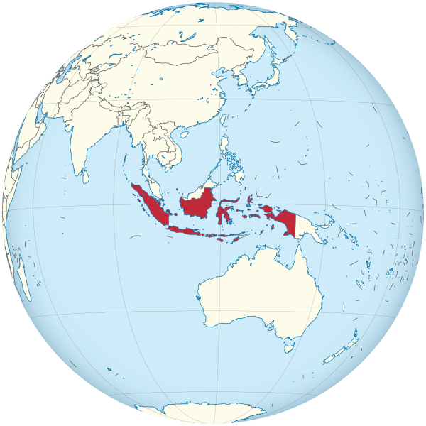
Indonesia location on the Asia map
The word “Indonesia” is made up of the two words “India” and “nesos”, which means island in Greek.
The toponym “Indonesia” became widespread after the congress of youth organizations in 1928. Prior to this, the republic on the map and in the broad public lexicon was called the Netherlands East Indies, as it was a colony of the Netherlands.
Location of Indonesia on the world map
Indonesia on the world map is located in the Eastern Hemisphere, a number of its islands are crossed by the zero parallel – the equator.
Geographical coordinates:
- Latitude: 11 ° S – 6° N ;
- Longitude: 95°– 141° E
The country is stretched from east to west for 5.1 thousand km. The length from north to south is three times less and is 1.7 thousand km.
The map of Indonesia has more than 17 thousand islands, but no more than 6 thousand are inhabited.
The archipelago state is mostly located on the Greater and Lesser Sunda Islands.
Climate
The close proximity to the equator and location in the equatorial climate zone determines the humid equatorial and subequatorial type of climate in Indonesia.
Due to the winds coming from the tropics to the equator, the climate of the republic is divided into two seasons: dry and wet. From December to April, the doge season is observed, during which most of the head of normal precipitation falls. The rains are torrential in nature, often accompanied by thunderstorms. From May to November there is a dry period during which precipitation can be short and infrequent.
The average annual air temperature in the plains of Indonesia is 26°C. Deviations associated with the change of seasons do not exceed 2-3°C.
Nature
The totality of living organisms of the republic is due to its biographical zoning . The Asian type of flora and fauna of the state was formed due to the fact that the western and northwestern islands were part of the Eurasian continent. From the southeast and east, the islands of present-day Indonesia were an integral part of Australia, which contributed to the development of the animal and plant world of the Australian type.
Indonesia borders on the map
Indonesia political map
Through the islands of Java and Sumatra of the Malay Archipelago, on the territory of which the Republic of Indonesia is located, about 15 straits pass, connecting the waters of the Pacific and Indian Oceans. The total area of the state is 1.9 million km². Of these, 1.8 million km² are on land, 0.1 million km² are inland waters.
Major rivers:
- Capua ;
- Mamberamo ;
- Sepik ;
- Barito .
The highest point of the republic is Puncak Jaya , the absolute height of which is about 5 thousand meters.
The island nation has both land and sea borders.
Land borders:
- In the southeast – Papua New Guinea;
- In the north – Malaysia;
- To the south is East Timor.
Maritime borders:
- Through the Singapore Strait with Singapore;
- Through the South China Sea with Vietnam;
- Through the Gulf of Thailand with Thailand and Cambodia;
- Across the Sulawesi Sea with the Philippines;
- Through the Timor Sea with Australia;
- Through the Philippine Sea from Palau;
- Through the Bay of Bengal with India.
Large islands on the map of Indonesia:
- New Guinea;
- Borneo;
- Sumatra;
- Java;
Relief
The territory of modern Indonesia is located at the junction of tectonic plates: Australian and Eurasian. In this regard, mountainous terrain prevails in the republic. Such large islands as Java and Sumatra have continuous linearly elongated mountain ranges. There is also high volcanic and seismic activity.
Most of the plains of Indonesia fall on the island of Kalimantan.
Hydro resources
Water resources on the map of Indonesia are represented by rivers, seas, lakes and reservoirs.
The largest number of rivers falls on the islands of New Guinea, Kalimantan and Java. The largest river of the state – Kapuas flows into the South China Sea.
The largest and one of the deepest lakes of the republic is Lake of volcanic origin Toba . Its depth is approx 500 метров.
There are 11 inter-island seas on the map of Indonesia.
Flora and fauna
The flora of the Indonesian islands is characteristic of the equatorial climate. Regardless of the altitude of the territory, humid tropical forests with evergreens predominate in the republic.
The most characteristic types of plants:
- Focuses;
- Arecaceae ;
- ferns;
- Bamboo;
- Pandanus;
At an altitude of over 3 thousand km, crooked forests, herbaceous plants and shrubs predominate.
The largest cities on the map of Indonesia
Jakarta
The capital of the Republic is the largest city on the map of Indonesia – Jakarta. The city is located on the island of Java on the coast of the Java Sea. The Ciliwung River divides the city into eastern and western parts. Jakarta is located below sea level, so during the rainy season the territory of the city is flooded.
Surabaya
At the mouth of the Mas River on the east coast of the island of Java is the city of Surabaya – the second largest city in the republic. The border of the city goes to the shore of the Madura Strait, where large seaports are located. In addition, Surabaya and the island of Madura are connected by the longest Indonesian bridge Suramadu .
Bandung
The city is located on the island of Java and is the administrative center of West Java. Bandung is a metropolis with over 2 million people. In terms of population, it is second only to Jakarta and Surabaya .
Bekasi
A major city on the map of the island of Java, through which two highways, an express road and a bus network pass. The city has over a million residents, whose main employment is in Jakarta. The city has developed trade, engineering and service industries.
Medan
The administrative center of North Sumatra on the map of the island of Sumatra is the city of Medan . The port city, in addition to the sea, has two airports of international importance. It is a large metropolis with a population of over 2 million people.
Tangerang
One of the major cities on the map of the island of Java is the millionaire city of Tangerang . Like Bekasi , Tangerang is a satellite city of the Indonesian capital. In addition to industrial enterprises, the map of the city has an international airport Soekarno-Hatta .
Tourist destinations
The island location of the state, climatic conditions and unusual relief make Indonesia a popular country for travelers.
For tourists from all over the world, not only 100 thousand km of beaches are open, but also unique ecosystems of tropical forests and coral reefs.
Sumatra
Sumatra is the second largest island in the Indian Ocean. Located on both sides of the equator in the westernmost part of the islands of the Indonesian archipelago. The island contains Lake Toba . Coral reefs are common along the coast of the island. A third of the territory is covered with tropical rainforests.
Kalimantan
The island is divided between Indonesia, Malaysia and Brunei. It is located in the center of the Malay Islands and is the third largest in the world. A large number of species diversity of flora and fauna makes Kalimantan attractive for tourists. Each forest ecoregion of the island is unique and has unexplored patches.
Java
The third largest island in Indonesia, along which the border of the republic passes. In addition to natural resources, travelers visit various historical and religious sites.
Bali
The island is located in the Lesser Sunda group . It is bordered by the Indian Ocean on the south side and the Pacific Ocean on the north side. The most developed beach and ecological elite tourism.
Sulawesi
The second largest island in Indonesia is Sulawesi. On the map, the island looks like a butterfly: 4 peninsulas stand out from the central part.
Noosa Tenggara
A province that includes several islands from the Lesser Sunda group . The largest of them are Sumbawa and Lombok . The province attracts tourists with its ethnic and religious diversity, as well as the rich underwater world.
Maluku
Maluku is a province that includes the islands of the Moluccas archipelago. “Spice Islands” are rich in a wide variety of exotic spices.
Papua
The island of New Guinea is divided into two parts. Papua – its western part, has a large number of untouched primeval territories.