Texas Hill Country Catastrophe: How System Failures Turned Summer Rain Into Deadly Tragedy

Introduction: Four Months of Rain in Hours
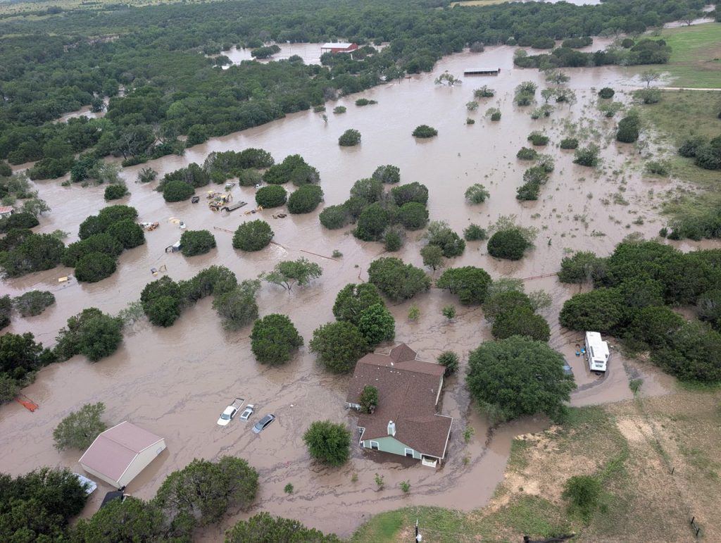
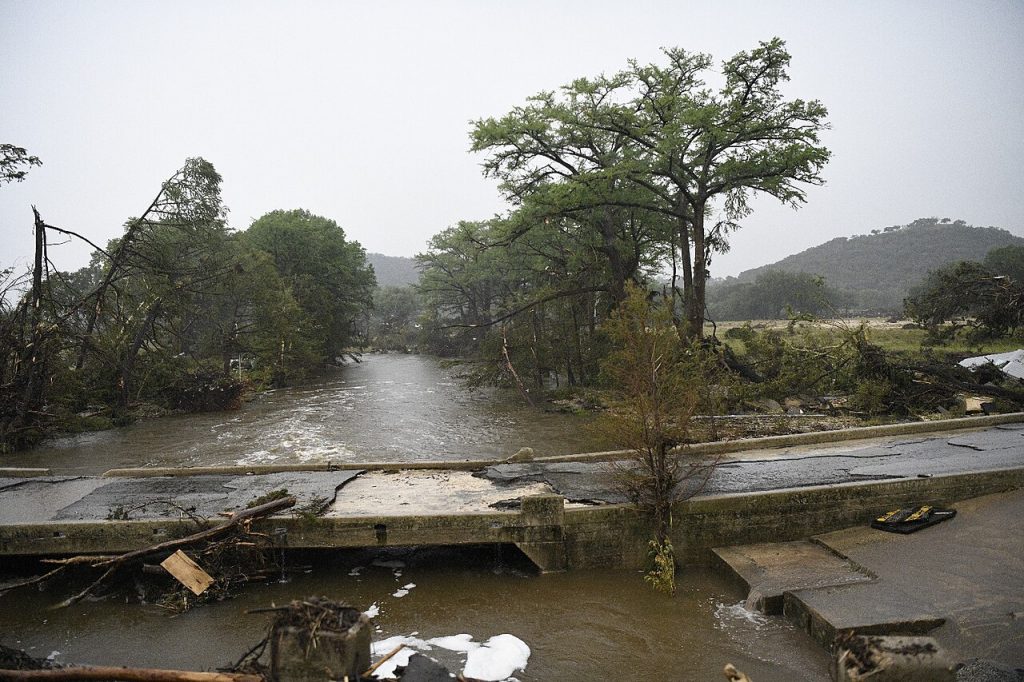
On July 4, 2025, America’s Independence Day, nature unleashed unprecedented fury on Central Texas. In mere hours, the Texas Hill Country region received rainfall equivalent to four months’ worth—over 1.8 trillion gallons of water. The result was catastrophic: 132 confirmed deaths, including 36 children, and over 100 people still missing.
This flood became the deadliest inland flooding event in the United States since the 1976 Big Thompson River disaster, surpassing even the destruction from Hurricane Helene in 2024.
Timeline of Catastrophe: When Every Minute Counted
July 3: First Warnings
1:18 PM CDT — National Weather Service issues flood watch for Kerr County 6:10 PM CDT — Weather Prediction Center warns of “significant impacts” from potential flooding
July 4: Day of Disaster
| Time | Event | Water Level (feet) |
|---|---|---|
| 1:14 AM | First “considerable” flash flood warning issued | – |
| 4:03 AM | Flash flood emergency declared for Hunt | – |
| 4:05 AM | Guadalupe River at Hunt | 21.99 |
| 5:10 AM | Hunt gauge stops working | 37.52 (record) |
| 5:34 AM | Flash flood emergency for Kerrville | – |
| 6:45 AM | River at Kerrville | 34.29 |
| 7:24 AM | Flash flood emergency for Comfort | – |
| 10:45 AM | River at Comfort | 35.26 |
Critical Fact: The Guadalupe River rose 26 feet in just 45 minutes near Hunt, where Camp Mystic was located.
Geography of Tragedy: Mapping the Devastation
Death Toll by County
| County | Deaths | Missing | Notable Features |
|---|---|---|---|
| Kerr | 106+ | 97 | Primary disaster zone, Camp Mystic |
| Travis | 9 | 3 | Lake Travis area |
| Kendall | 8 | 0 | Comfort – warning system worked |
| Burnet | 5 | 1 | Secondary impact zone |
| Williamson | 3 | 0 | Peripheral areas |
| Tom Green | 1 | 0 | Minimal damage |
| Total | 132+ | 101 | – |
Rainfall Analysis
| Location | Rainfall Amount | Time Period |
|---|---|---|
| Northwest of Streeter | 20.33 inches (516 mm) | ~12 hours |
| Kerrville | 6.5 inches (170 mm) | 3 hours |
| Regional average | 5-11 inches (130-280 mm) | 6-8 hours |
Camp Mystic: Tragedy at the Children’s Camp
 Background of Fatal Decisions
Camp Mystic, a Christian summer camp for girls, became the epicenter of human loss. 27 people (including director Dick Eastland) died at this facility hosting 750 children.
Timeline of Regulatory Failures:
| Year | FEMA Action | Consequences |
|---|---|---|
| 2011 | Placed in special flood hazard area | Required flood insurance |
| 2013 | Removed 15 buildings from hazard zone | Reduced oversight |
| 2019-2020 | Removed 15 more buildings | Complete removal of restrictions |
Critical Detail: In the late 1980s, the camp installed an automatic water level warning system, but authorities shut it down in the 1990s due to “unreliability.”
System Failures: Anatomy of a Preventable Disaster
1. Absence of Early Warning Systems
Kerr County was the only major county in “Flash Flood Alley” without an independent warning system.
Comparison with Neighboring Regions:
| County | Warning System | Cost | Deaths |
|---|---|---|---|
| Kerr | SMS alerts only | $0 | 106+ |
| Kendall (Comfort) | Automatic sirens + satellite link | $60,000 | 0 |
2. Communication Delays
Timeline of Communication Failure:
- 4:22 AM — Ingram firefighter requests sheriff to warn residents
- 6:00 AM — First CodeRED message sent (delay: 1 hour 38 minutes)
- 10:00 AM — Some messages don’t arrive until this time
3. FEMA Response Issues
Emergency Call Response Statistics:
| Period | Percentage Answered | Cause |
|---|---|---|
| Pre-disaster | ~95% | Normal operations |
| July 4-6 | ~60% | Call center staff shortage |
| July 7-9 | ~75% | Partial restoration |
Cause: Secretary Kristi Noem had not renewed contracts with four primary call centers.
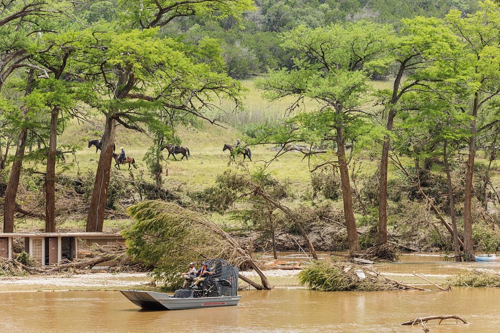
Rescue Operations: Heroism Amid Chaos
International Aid Response
Participating States and Countries:
| State/Country | Number of Rescuers | Specialization |
|---|---|---|
| Texas | 2000+ volunteers | Coordination |
| Mexico | 13 + dogs | Search and rescue dogs |
| California | 18 | Hurricane Katrina, 9/11 experience |
| Colorado | 48 + 4 dogs | Multi-disciplinary team |
| Arkansas | 22 | Aviation support |
| Ohio | 3 + 2 dogs | K-9 search |
Heroic Moments
Scott Ruskan, U.S. Coast Guard rescue swimmer, coordinated the evacuation of 165 people, giving up his seat on the rescue helicopter.
Rescue Operation Statistics:
- Total rescued: 850+ people
- Rescued from rooftops and trees: 167 people
- River distance searched: 26 miles (42 km)
Climate and Meteorological Factors
 Climate Change Connection
A study published July 7 on Zenodo by three climatologists showed:
- 7% increase in moisture content of meteorological conditions compared to similar past events
- Comparison periods: 1950-1986 vs 1987-2023
- Conclusion: “Natural variability alone cannot explain the changes in precipitation”
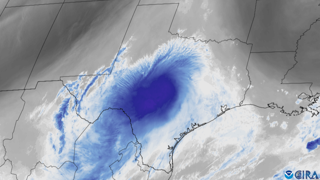
Tropical Storm Barry as Catalyst
On July 3, 2025, remnants of Atlantic Tropical Storm Barry merged with tropical moisture from the eastern Pacific, creating a “mesoscale convective vortex” over Central Texas.
Economic Impact and Recovery
Financial Aid
| Organization | Contribution | Type of Aid |
|---|---|---|
| H-E-B | $5 million | Mobile kitchens, supplies |
| T-Mobile | $500,000 | General support |
| Walmart + Sam’s Club | $500,000 | Grants and donations |
| Community Foundation | $30 million | General relief fund |
Federal Support
- 75% of Texas emergency operations budget covered by federal funds
- Disaster Recovery Center opened in Kerrville July 10
- President Trump signed federal disaster declaration July 6
Conspiracy Theories and Misinformation
Flood damage in Kerrville
Wave of Conspiracy Theories
Following the flood, social media spread theories about:
- Weather control by government
- Cloud seeding as cause of disaster
- “Fake weather” (Congresswoman Marjorie Taylor Greene)
Real Consequences:
- Rainmaker company received death threats
- July 6: Man damaged radar system in Oklahoma City
- Bill introduced to make weather alteration a felony
Lessons from Catastrophe: What Must Change
1. Early Warning Systems
- Mandatory implementation of automatic warning systems in all “Flash Flood Alley” counties
- Minimum cost: $60,000 per county
- Potentially saved lives: dozens per event
2. Construction Regulation in Risk Zones
- Stricter control over FEMA flood map exemptions
- Independent review of all risk zone status change requests
3. Federal Response
- Review of FEMA contract approval policy for amounts over $100,000
- Create mechanisms for rapid resource deployment without bureaucratic delays
Analysis: The Price of Inaction
Warning System Effectiveness Comparison
| Location | Warning System | Response Time | Casualties |
|---|---|---|---|
| Kerr County | None | 6+ hours | 106+ deaths |
| Comfort, Kendall County | Automated sirens | Immediate | 0 deaths |
| Hunt area | None | 6+ hours | 27+ deaths at Camp Mystic |
FEMA Response Timeline Issues
| Critical Decision | Normal Timeline | Actual Timeline | Impact |
|---|---|---|---|
| Deploy Urban Search & Rescue | Within 12 hours | 72+ hours | Delayed rescues |
| Activate call centers | Immediate | 3+ days | Missed distress calls |
| Pre-position resources | 24 hours before | Not done | Slower response |
Investigative Findings: Key Systemic Problems
1. Regulatory Capture at FEMA
Between 2011-2020, 30 buildings were removed from Camp Mystic’s flood hazard designation through appeals process, despite being in “extremely hazardous” floodway.
2. Local Government Negligence
- 2016: Sheriff advocated for warning system
- 2017-2018: County requested federal grants for equipment (denied)
- 2021: American Rescue Plan Act funds available (unused)
3. Federal Workforce Reductions
- San Angelo NWS office: Multiple vacancies including meteorologist-in-charge
- San Antonio office: No warning coordination meteorologist
- Vacancy rates “roughly doubled” since January 2025
The Human Cost: Stories Behind the Statistics
Camp Mystic Victims
- 27 total deaths at the camp
- 750 girls were in attendance
- Dick Eastland, camp director since 1974, among the victims
- 165 people evacuated by single Coast Guard swimmer
Emergency Response Heroes
- Scott Ruskan (Coast Guard): Saved 165 people
- Mexican firefighters: Traveled from Acuña with search dogs
- 2,000+ volunteers: Converged on Kerr County
- 13 states + Mexico: Provided rescue teams
Conclusion: The Preventable Tragedy
The July 2025 Texas floods serve as a stark reminder of how systemic failures can transform a natural disaster into a humanitarian catastrophe. 132 lives lost represents not just statistics, but the consequence of specific decisions and omissions:
- Refusal to implement a $60,000 warning system in a county where 106 people died
- Regulatory favoritism for a camp in an “extremely hazardous” zone
- Bureaucratic delays in federal emergency response
The Primary Lesson: In an era of climate change and intensifying extreme weather events, investments in warning systems and preparedness are not luxury items—they are life-saving necessities. The cost of inaction is measured in human lives, and that price proves unacceptably high.
The Texas Hill Country disaster demonstrates that modern emergency management requires three critical elements: robust early warning systems, strict adherence to safety regulations, and rapid federal response capabilities. When any of these fail, the consequences are measured in lives lost and families shattered.
As of July 14, 2025, search operations for the missing continue, while investigative committees begin work to establish all circumstances of the tragedy.
Sources: Based on official reports from the U.S. National Weather Service, FEMA data, local government reports, and eyewitness accounts compiled by CNN, The New York Times, and PBS News journalists.
By Unknown author – https://x.com/USCGHeartland/status/1941569535238340640/photo/2,
By wckitchen – https://www.flickr.com/photos/202965276@N07/54639631105/, CC BY 4.0, Link
By GOES imagery: CSU/CIRA & NOAA – Catastrophic Flooding in Texas Hill Country,
By World Central Kitchen – https://www.flickr.com/photos/wckitchen/54643324542/, CC BY 4.0, Link
By World Central Kitchen – Flickr , CC BY 4.0
By Zhongyu Han and Hatim O. Sharif – https://www.mdpi.com/2073-4441/12/10/2884, CC BY 4.0,
By Weather Prediction Center at NOAA – https://www.wpc.ncep.noaa.gov/archives/web_pages/ero/ero.shtml
Adams, Christopher (July 9, 2025) [July 6, 2025]. “MAP: Where have flash flooding fatalities been confirmed in Texas?”. kxan.com. Retrieved July 9, 2025.