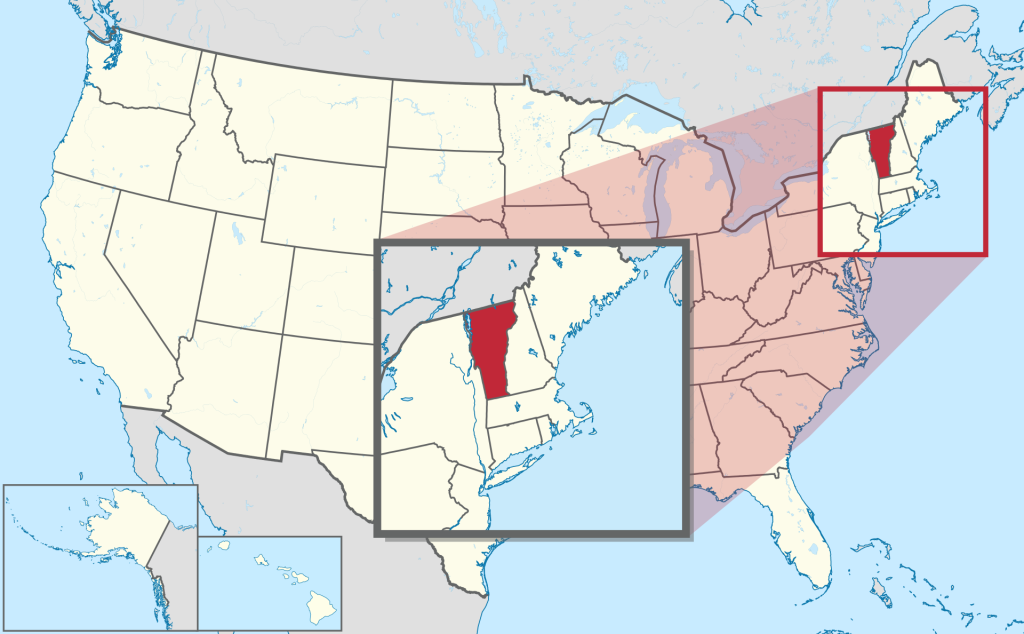
Vermont map, USA
General map of Vermont live
The geographical position of the state of Vermont on the map of the USA
Vermont is a state in the northeastern United States of America. The administrative center is Montpelier. The city is located in the central part of the state, in a hilly area near the spurs of the Green Mountains – the ridge of the Appalachian mountain system.
The state of Vermont on the map can be found in the northeastern part of the United States, next to the states of New Hampshire and Massachusetts, which separate it from the Atlantic Ocean. To the west, Vermont borders the state of New York, and to the north it shares a common border with the Canadian province of Quebec.
On the map of Vermont, you can determine the geographical landmarks of the state. To the west and northwest, Lake Champlain separates Vermont from New York State. Between Vermont and New Hampshire flows the Connecticut River, the west bank of which marks the border of the state.
Geographical characteristic
The state of Vermont on the map looks elongated from north to south. Its territory is divided into 6 geographical regions:
- Green mountains, which are part of the Appalachian mountain system. The ridge stretches for 260 km from south to north just west of the central part of the state. The highest peak is Mount Mansfield, 1340 m. The summit is located in the city of Underhill, Chittenden County.
- In the southwestern part of the state, the Green Mountains are bordered by the Taconic Mountains, which are smaller than the former in height. The highest point – Mount Equinox reaches 1175 m above sea level. The summit is located in the city of Manchester in Burlington County.
- North of the Taconic Mountains and west of the Greens lies the Champlain Lowland, a vast plain of fertile land. It extends around the lake of the same name and captures part of the state’s northern border with Canada.
- South and east of the Taconic Mountains, the Champlain Lowlands merge into the Vermont Valley. Its territory is crossed by many small rivers and streams.
- East of the Green Mountains begins the foothills of Vermont. It is a plain that turns into hills. Along the foothills flows the Connecticut River, on the opposite bank of which the state of New Hampshire originates.
- The foothills of Vermont, gradually rising, pass into the Northeast Highlands. It is known for its granite peaks, cut by streams.
Relief. The maximum height above the sea is 1340 m (Mount Mansfield), the minimum is 30 m (Lake Champlain). 78% of the area of the state is occupied by forests.
Major cities of Vermont on the map
Despite the fact that Montpelier is the administrative center, it is significantly inferior to other cities in the state in terms of size and population. The following settlements can be attributed to large ones.
Burlington
The largest city is located in the eastern part of the state, between Lake Champlain and the Green Mountains. Burlington is based on the coast of the lake, north of Shelburne Bay. This location is the reason for frequent local snow squalls, which result in up to 33 cm of snow falling in 12 hours.
South Burlington
The city is the seat of Chittenden County, which surrounds Burlington to the south and east. To the east and southeast, the Green Mountains begin, and in the southwest direction, Lake Champlain. The Winooski River flows through the northern part of the city, one of the main rivers in the state of Vermont.
Essex
Vermont’s third largest city is also in Chittenden County. Essex is located in the central part and is washed by the Winooski River on the south side. On the territory of the city is the reservoir of Indian Brook, which is the center of the reserve of the same name.
Rutland
Rutland is the county seat of Rutland County. It is located 110 km from the border with Massachusetts, 56 km west of the border with New Hampshire and 48 km from the eastern border of New York State.
Sources:
| № | Locality | State | Coordinates | Stations |
|---|---|---|---|---|
| 1 | Weston | Vermont | - | 0 |
| 2 | Stowe | Vermont | - | 0 |
| 3 | St Johnsbury | Vermont | - | 0 |
| 4 | Springfield | Vermont | - | 0 |
| 5 | South Royalton | Vermont | - | 0 |
| 6 | Shady Rill | Vermont | - | 0 |
| 7 | Rutland | Vermont | - | 0 |
| 8 | Queen City Park | Vermont | - | 0 |
| 9 | North Springfield | Vermont | - | 0 |
| 10 | McIndoe Falls | Vermont | - | 0 |
| 11 | Marlboro | Vermont | - | 0 |
| 12 | Willoughby | Vermont | - | 0 |
| 13 | St Johnsbury | Vermont | - | 0 |
| 14 | Middlebury (village) | Vermont | - | 0 |
| 15 | East Kansas | Vermont | - | 0 |
| 16 | Bromley Village | Vermont | - | 0 |
| 17 | Rutland | Vermont | - | 0 |
| 18 | East Middlebury | Vermont | - | 0 |
| 19 | East Haven | Vermont | - | 0 |
| 20 | East Corinth | Vermont | - | 0 |
| 21 | Brownington Center | Vermont | - | 0 |
| 22 | Brattleboro | Vermont | - | 0 |
| 23 | Burlington | Vermont | - | 0 |
 The Guide Maps
