Kansas map, USA
General map of Kansas live
-

- Where is Kansas located
-

- Kansas state map with cities and highways
-

- Large administrative map of Kansas state with roads highways and cities
-

- Kansas with relief and rivers
-

- Large detailed roads and highways map of Kansas state with national parks all cities towns and villages


-

- large administrative-map of Kansas

-

- Kansas counties with borders

View this map of Kansas state with roads, streets and houses. Located in the central part of the United States, Kansas is a fascinating state that is full of history and culture. From its rolling hills to its wide open plains, this state offers travelers something unique to discover. The political and physical maps of Kansas reveal much about the geography, culture, and history of this amazing place. Furthermore, there are also plenty of things to do in Kansas for those who want to explore it further. Lastly, the four largest cities in Kansas offer plenty of activities for tourists and locals alike.
Where is the state of Kansas?
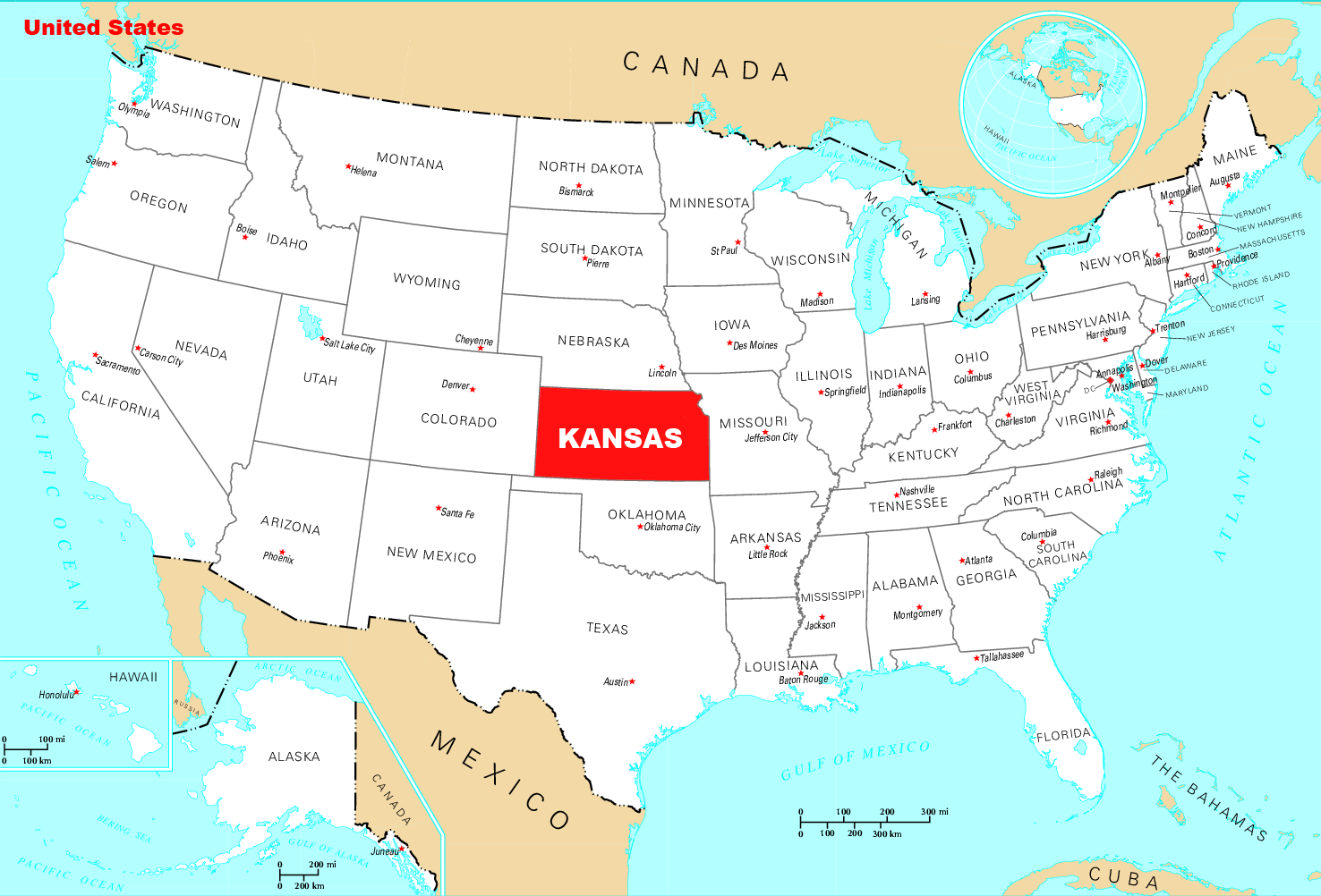
Location map of Kansas in the US.
The state of Kansas is located in the central part of the United States and lies between Nebraska to the north, Colorado to the west, Oklahoma to the south, and Missouri to the east. It has a land area of 82,277 square miles and a population just over 2 million people. The capital city is Topeka while Wichita is its largest city.
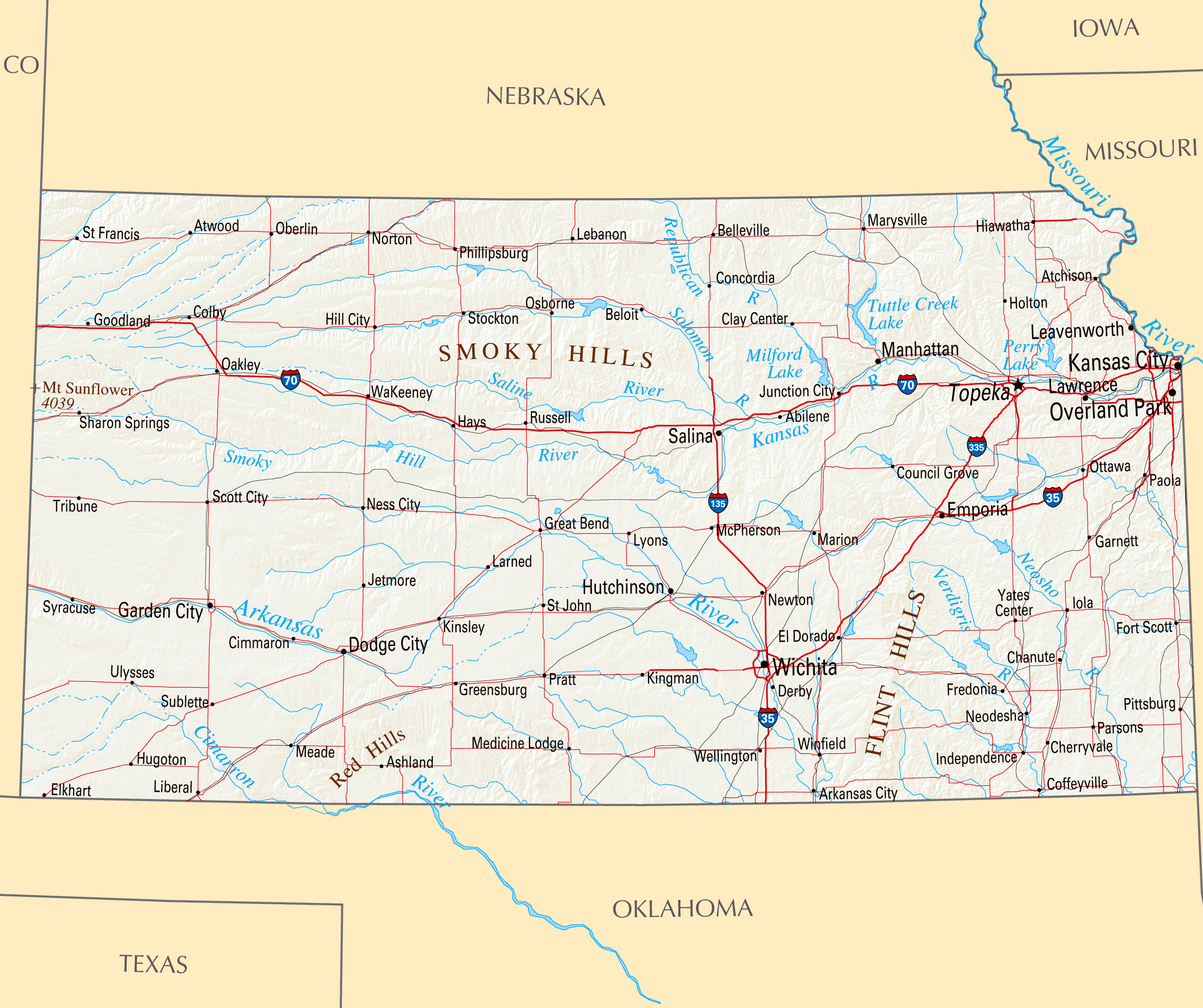
What can be seen on the political map?

Map of Kansas counties with borders and names
On a political map of Kansas you will find 105 counties as well as all cities larger than 5500 people. All major rivers including the Missouri and Arkansas rivers are highlighted as well as major highways like I-70 which bisects the state from east to west. Other important landmarks such as national parks (Tallgrass Prairie National Preserve) or military bases (Fort Leavenworth) are also shown on this type of map.
What can be seen on physical map?
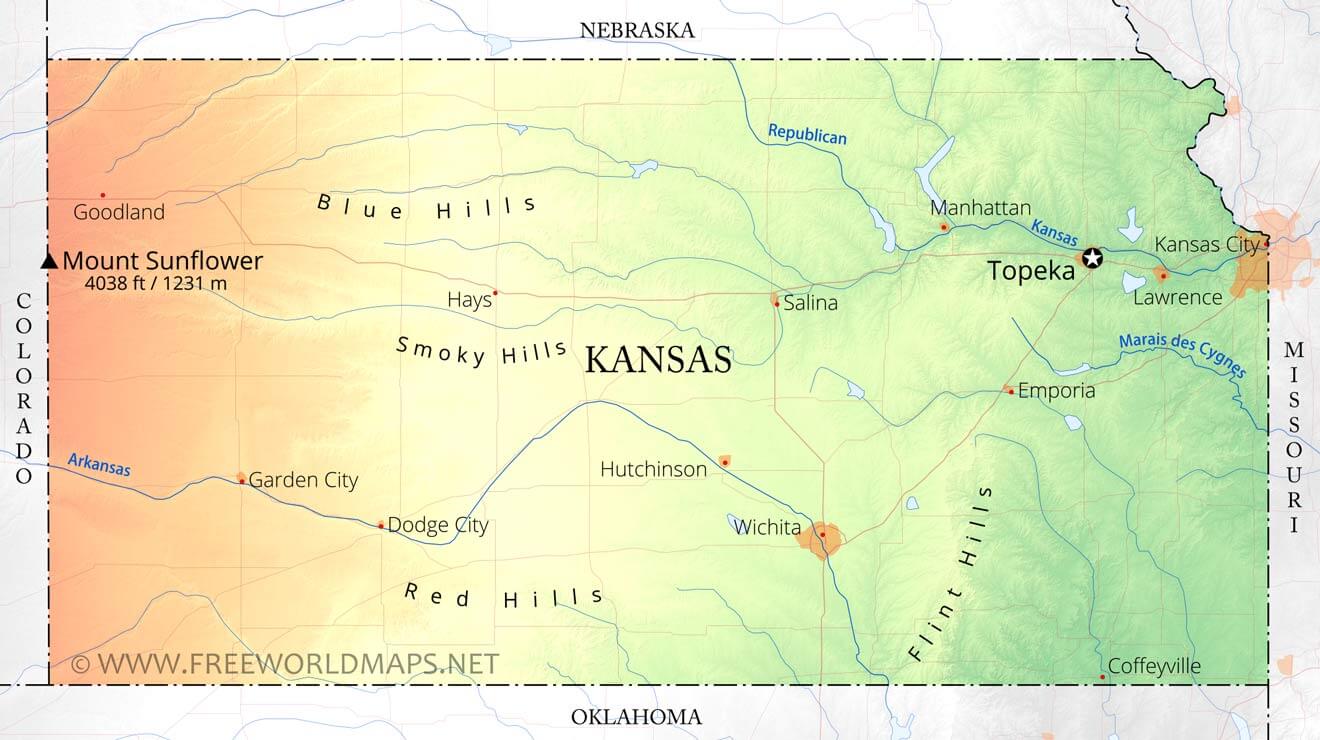
Map of Kansas with relief and rivers
The physical map reveals much about what makes up this great state. The most prominent feature that stands out on this type of map is Flint Hills – an area known for its rolling hills and tall grasses that run from eastern Kansas into Oklahoma along I-35 southward toward Dallas-Ft Worth Metroplex region. Visitors will also notice two major bodies of water – Lake Mead which forms at least one border with Nebraska and Kanopolis Lake which serves as an important reservoir for nearby towns such as Ellsworth along I30 highway. Additionally, prairie lands dominate much of western portion while eastern side features wooded areas near Ozark Mountains located across border with Missouri in southeast corner near Joplin metro region. The Kansas state map is a great tool to avoid getting lost in an unfamiliar city.
Things to do in Kansas
Travelers can find plenty to do while exploring Kansas! From checking out some local museums such as Museum Of World Treasures in Wichita or Nelson Atkins Museum Of Art in Kansas City; visiting historical sites related to Wild West like Boots & Saddles Memorial Trail or Fort Larned Old Guard Station; spending time outdoors – canoeing down Kaw River near Topeka or taking a hike through Tallgrass Prairie National Preserve; going shopping at Legends Outlet Mall or Oak Park Mall; touring some breweries like Free State Brewing Company in Lawrence; attending concerts at Starlight Theatre or Sprint Center Arena in downtown KCMO…the possibilities are endless! The reference map of Kansas state serves as a starting point in the world of traveling around the city.
Four big cities of this State
Kansas state map with cities and highways
Topeka – Serving as capital city since 1856 Topeka boasts strong cultural heritage from Wild West era with notable sites such as Ward Meade Historic Site built during Civil War times featuring log cabins & Victorian-style homes surrounded by gardens; Museum Of History displaying artifacts related early settlers; Mulvane Art Museum & Zoo showcasing artistic works & wildlife etc…
Wichita – Often referred “Air Capital Of World” due presence aerospace industry Wichita houses sights like Old Town district filled with 19th century buildings now converted into restaurants & shops; Sedgwick County Zoo ranking among top 10 zoos nation-wide & Botanica Gardens where visitors can watch colorful butterflies freely flutter around flowers etc…
Lawrence – Home place University of Kansas nicknamed “Jayhawks” when not cheering team many students enjoy nightlife offered by Massachusetts Street packed bars cafes art galleries music venues etc…
Kansas City – Last but not least we got KCMO – where American jazz was born – home numerous legendary artists like Charlie Parker all whom left timeless legacy live bands playing blues gospel jazz still found regular basis St Louis Cathedral former courthouse Mississippi River banks cobblestone streets Westport entertainment district offer countless opportunities fun leisure activities throughout year!
| № | Locality | State | Coordinates | Stations |
|---|---|---|---|---|
| 1 | Walnut Grove Mobile Home Park | Kansas | - | 0 |
| 2 | Silver Spur Mobile Home Park | Kansas | - | 0 |
| 3 | Topeka | Kansas | - | 0 |
| 4 | Rolling Meadows Mobile Home Park | Kansas | - | 0 |
| 5 | Overland Park | Kansas | - | 0 |
| 6 | Overland Park | Kansas | - | 0 |
| 7 | North Topeka | Kansas | - | 0 |
| 8 | Golden Spur Mobile Home Park | Kansas | - | 0 |
| 9 | Green Acres Park Mobile Home Park | Kansas | - | 0 |
| 10 | Friendly Acres Mobile Home Park | Kansas | - | 0 |
| 11 | Dodge City | Kansas | - | 0 |
| 12 | Country Lane Mobile Home Park | Kansas | - | 0 |
| 13 | Colonial Gardens Mobile Homes | Kansas | - | 0 |
| 14 | Conestoga Estates Mobile Home Park | Kansas | - | 0 |
| 15 | Adams Heights Mobile Home Park | Kansas | - | 0 |
| 16 | Wichita | Kansas | - | 0 |