Wisconsin map, USA
General map of Wisconsin live
Wisconsin is a US state located in the Midwest region. The territory of the state is administratively divided into 72 districts.
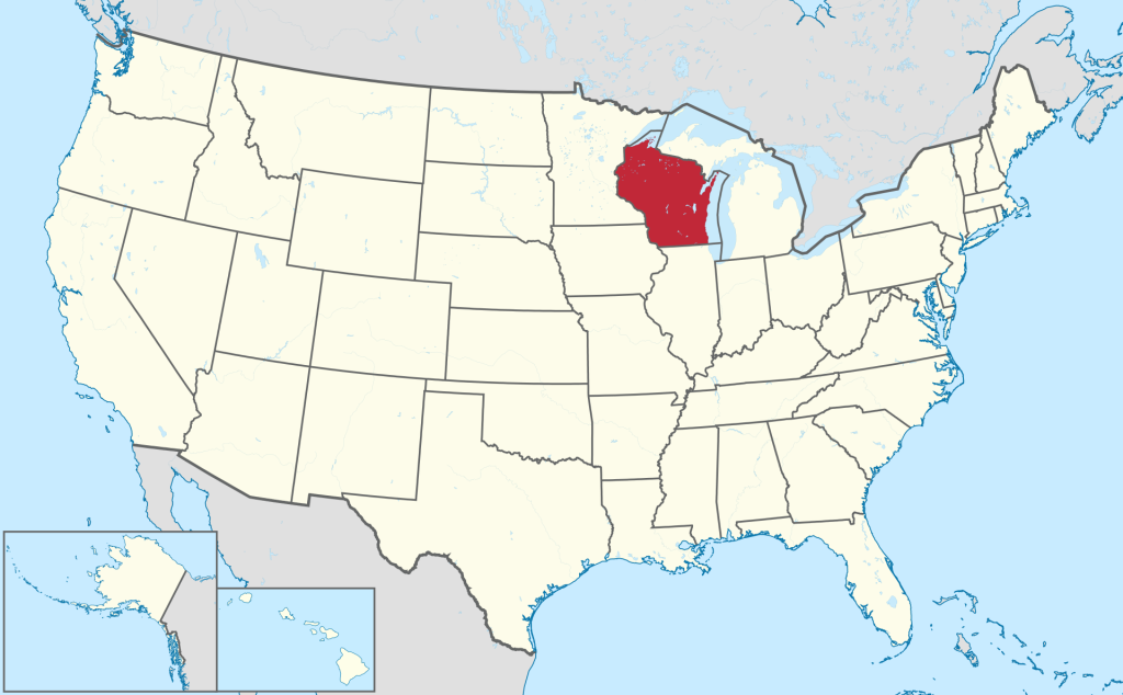
The geographical position of the state of Wisconsin on the map of the USA
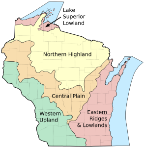
The area of the state is about 170 thousand km 2 (65,496 sq. miles). The territory of Wisconsin on its geographical map contains the following areas (zones):
- Central Plain;
- Northern Highlands bordering the state of Michigan;
- Northern lowlands bordering Lake Superior and Canada;
- Western Uplands bordering Iowa and Minnesota;
- Eastern hills and lowlands bordering Lake Michigan.
Extensive thickets of deciduous forests have been preserved on the Central Plain. In places you can see sandstone hills. Picturesque cliffs near the town of Wisconsin Dells . There is a gorge in the Central Plain along which the Wisconsin River flows .
The water border of the Northern Highlands with Michigan is along the Menominee River. The area is covered with mixed forest. There are many lakes on this rolling plateau, which is why the area is often referred to as the “Lake District”. It also contains the highest point in the state – the 595-meter mountain Timms Hill. Maples, spruces, birches, aspens, lindens grow in forests almost throughout the entire territory of the zone. “National Forest” Chequamegon-Nicolet with an area of over 6 thousand km 2 with a rich fauna is a tourist attraction.
The coastal lowland near Lake Superior, 30–35 km (18-21,75 miles) wide, gradually decreases as it approaches the reservoir. It is covered with ash, birch and aspen forests, but in places you can also see swampy areas.
The western upland is indented by numerous rivers and streams. The natural borders with Minnesota and Iowa are water, passing along the Santa Cruz and Mississippi rivers, respectively. The hills abound with caves, rocks, and ravines. The “Devil’s Lake” is popular among tourists. Lands not used for agricultural land are occupied by forests. This region is sparsely populated.
The eastern zone, as seen on the map , has an extensive border with Lake Michigan. Mixed relief prevails: low hills are surrounded by plains. Here is the largest lake in the state – Winnebago with an area of 550 km 2 (212,36 sq mi). The vast majority of the state’s population lives in the lowland towns of this zone.
Major cities of Wisconsin on the map
Milwaukee
The administrative center , port and the largest city of the state is Milwaukee . It is in the middle of the US Midwest region, on the shores of Lake Michigan, at the confluence of the Menomonee , Muluoka , and Kinnikinnick rivers. the small rivers Ruth River and Lincoln Creek flow into the city . The area of the city is about 251 km2 (96,91 sq miles) and the relief is mostly flat.
Madison
Madison is the capital of Wisconsin and the administrative center of Dan County. The city is located in the southern part of the state. The city center is located on the isthmus between two lakes – Mendota and Menona. The water area of the latter is the lowest point of the city . Within its boundaries there is another lake – Wingra. The highest point of the city ‘s relief is in its far western part. The area of Madison is about 263 km2 (101,54 sq mi)
Green Bay
The city is the county seat of Brown County on Green Bay , an arm of Lake Michigan. The area of the city is over 144 km2 (55,6 sq miles). It is located at an altitude of 177 m above sea level. The humid continental climate of Green Bay causes sharp weather boundaries between seasons.
Kenosha
The city of Kenosha is the administrative center of the district of the same name. Like Milwaukee , it is located on the shores of Lake Michigan. The area of the city is over 72 km2 (27,8 sq mi). Kenosha is halfway between Milwaukee and Chicago. The climate is humid continental.
Racine
Racine is the administrative district of the same name, also located on the shores of Lake Michigan. The area of city is over 40 km 2 (15,44 sq mi). The continental climate of Racine causes warm, but short, summers and cold winters.
| № | Locality | State | Coordinates | Stations |
|---|---|---|---|---|
| 1 | Welch Point (historical) | Wisconsin | - | 0 |
| 2 | Verona | Wisconsin | - | 0 |
| 3 | Tomahawk | Wisconsin | - | 0 |
| 4 | Sun Prairie | Wisconsin | - | 0 |
| 5 | Sturgeon Bay | Wisconsin | - | 0 |
| 6 | Stone Lake | Wisconsin | - | 0 |
| 7 | Potosi | Wisconsin | - | 0 |
| 8 | Pewaukee | Wisconsin | - | 0 |
| 9 | Oak Creek | Wisconsin | - | 0 |
| 10 | Mukwonago | Wisconsin | - | 0 |
| 11 | Milton | Wisconsin | - | 0 |
| 12 | Mequon | Wisconsin | - | 0 |
| 13 | Legend Lake | Wisconsin | - | 0 |
| 14 | Janesville | Wisconsin | - | 0 |
| 15 | Grafton | Wisconsin | - | 0 |
| 16 | Mequon | Wisconsin | - | 0 |
| 17 | Maples Mobile Home Park | Wisconsin | - | 0 |
| 18 | Edgerton | Wisconsin | - | 0 |
| 19 | Freistadt | Wisconsin | - | 0 |
| 20 | Fox River | Wisconsin | - | 0 |
| 21 | Elm Tree Corners | Wisconsin | - | 0 |
| 22 | Edgerton | Wisconsin | - | 0 |
| 23 | De Forest | Wisconsin | - | 0 |
| 24 | Cottage Grove | Wisconsin | - | 0 |
| 25 | Chippewa Falls | Wisconsin | - | 0 |
| 26 | Castle Rock | Wisconsin | - | 0 |
| 27 | Boulder Junction | Wisconsin | - | 0 |
| 28 | Baraboo | Wisconsin | - | 0 |
| 29 | Acacia Falls Mobile Home Court | Wisconsin | - | 0 |
| 30 | Madison | Wisconsin | - | 0 |
| 31 | Milwaukee | Wisconsin | - | 0 |
 The Guide Maps


