Arizona map, USA
General map of Arizona live
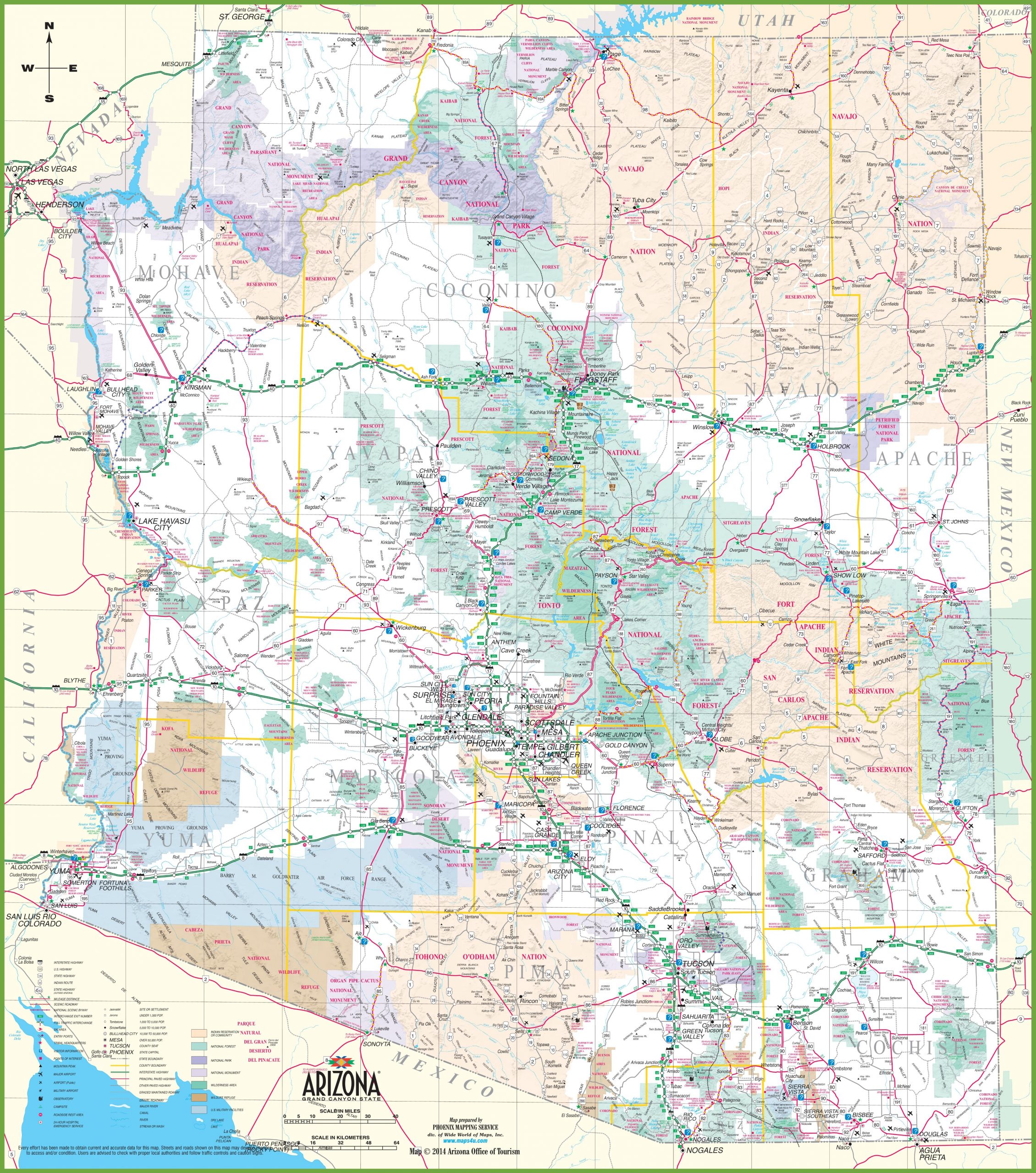
Large detailed map of Arizona
Location of Arizona in the United States
The state of Arizona on the map is located in the southwestern part of the United States. Its county seat and largest city is Phoenix. On the map of Arizona, it is located almost in the center, with a slight shift to the south.
Neighboring Arizona on the map are:
- in the west – California, Nevada;
- to the east, New Mexico;
- in the north – Utah.
From the south, Arizona on the map has a border with Mexico.
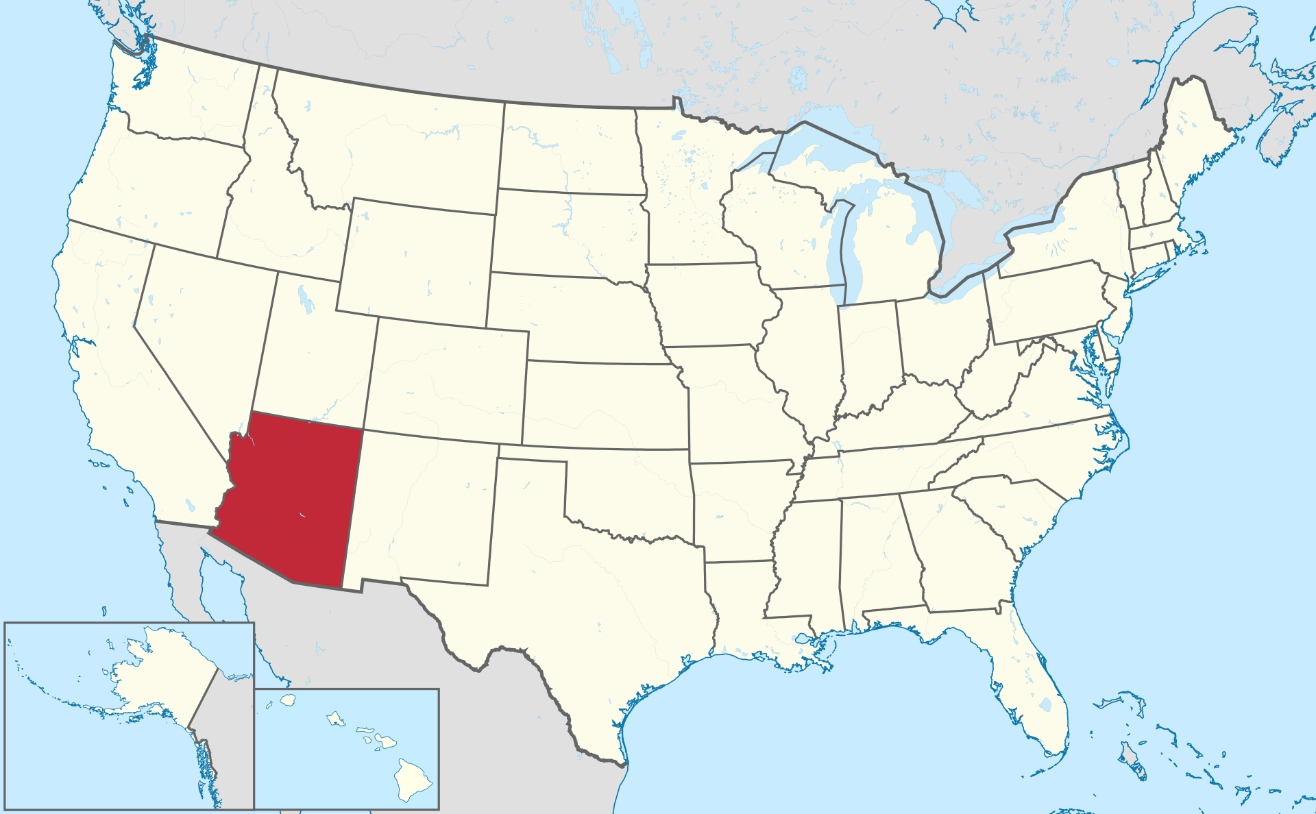
Location map of Arizona in the US.
On the physical map of Arizona , you can see that a significant part of its territory is brown. Arizona is part of the mountainous states of the United States. Most of its territory falls on mountains, plateaus and deserts and is the basin of the Colorado River, the region’s largest waterway.
The southwest of Arizona is occupied by the Sonoran Desert , within which the largest cities of Phoenix and Tucson are located . To the northwest lies the Mojave Desert. In the north of Arizona, the Painted Desert Desert is located on the Colorado Plateau, a small share in the southeast of the map of Arizona is occupied by the Chihuahua Desert.
Major cities of Arizona on the map
Phoenix
The capital of the state of Phoenix is the largest administrative center in terms of population not only of Arizona , but also among all the state capitals of the country. With a population of 1.66 million people. it is the fifth largest metropolitan area in the United States by population. Phoenix is one of the largest cities in the US in terms of area. The Phoenix agglomeration, which includes cities and towns, with a population of 4.86 million inhabitants, is the fifth among such entities in the country.
Tucson
Tucson is the second largest and most important city on the map of Arizona. Population 542 thousand people. Located 174 km southeast of Phoenix, 97 km north of the border with Mexico, at an altitude of 806 m above sea level. On a map of Arizona, this is the Sonoran Desert. It is surrounded by the peaks of 5 mountain ranges. The city itself stretches along the banks of the drying up river Santa Cruz. The city is home to the University of Arizona.
Mesa
Arizona ‘s third largest city is part of the Greater Phoenix, being its suburbs. With a population of 508,000, it is the state’s third city and the largest in the US that is not a county seat. U.S. urban explorers have described Mesa as “America’s most conservative city “.
Chandler
According to the 2020 census, Chandler has 275,000 residents. On a map of Arizona , it is located next to Phoenix, with which it borders to the west, and Mesa to the north. The city is named after its founder. Thanks to the emergence of enterprises in the region – giants of the computer and communications industry, it has become one of the fastest growing cities Arizona and USA.
Glendale
In 2020, the number of residents of Glendale reached 248 thousand people. Included in the Phoenix agglomeration “Valley of the Sun”. The city has a US Air Force base. It houses famous teams and stadiums from the National Football League and the National Hockey League representing Arizona. There are several universities.
| № | Locality | State | Coordinates | Stations |
|---|---|---|---|---|
| 1 | Gilbert | Arizona | - | 0 |
| 2 | Chandler | Arizona | - | 0 |
| 3 | Tucson | Arizona | - | 0 |
| 4 | Mesa | Arizona | - | 0 |
| 5 | Phoenix | Arizona | - | 0 |
Popular Reference Pages