Map of United States (USA)
USA map online
| № | Locality | State | Coordinates | Stations |
|---|---|---|---|---|
| 1 | Abilene | Texas | - | 0 |
| 2 | San Diego | Topography California | - | 0 |
| 3 | Portland | Oregon | - | 0 |
| 4 | Burlington | Vermont | - | 0 |
| 5 | Southaven | Mississippi | - | 0 |
| 6 | Jackson | Mississippi | - | 0 |
| 7 | Gulfport | Mississippi | - | 0 |
| 8 | Biloxi | Mississippi | - | 0 |
| 9 | Sterling Heights | Michigan | - | 0 |
| 10 | Warren | Michigan | - | 0 |
| 11 | Chicago | Illinois | - | 0 |
| 12 | Joliet | Illinois | - | 0 |
| 13 | Bridgeport | Connecticut | - | 0 |
| 14 | Baton Rouge | Louisiana | - | 0 |
| 15 | Thornton | Colorado | - | 0 |
| 16 | Arvada | Colorado | - | 0 |
| 17 | Lakewood | Colorado | - | 0 |
| 18 | Fort Collins | Colorado | - | 0 |
| 19 | Denver | Colorado | - | 0 |
| 20 | Little Rock | Arkansas | - | 0 |
| 21 | Boise | Idaho | - | 0 |
| 22 | Tuscaloosa | Alabama | - | 0 |
| 23 | Mobile | Alabama | - | 0 |
| 24 | Birmingham | Alabama | - | 0 |
| 25 | Montgomery | Alabama | - | 0 |
| 26 | Huntsville | Alabama | - | 0 |
| 27 | Grand Rapids | Michigan | - | 0 |
| 28 | Detroit | Michigan | - | 0 |
| 29 | Plano | Texas | - | 0 |
| 30 | Anaheim | California | - | 0 |
| 31 | Wichita | Kansas | - | 0 |
| 32 | Madison | Wisconsin | - | 0 |
| 33 | Gilbert | Arizona | - | 0 |
| 34 | Honolulu | Hawaii | - | 0 |
| 35 | New Orleans | Louisiana | - | 0 |
| 36 | Aurora | Colorado | - | 0 |
| 37 | Atlanta | Georgia | - | 0 |
| 38 | Sacramento | California | - | 0 |
| 39 | Milwaukee | Wisconsin | - | 0 |
| 40 | Chandler | Arizona | - | 0 |
-
")
- USA map with state borders and names
-
")
- USA map with main roads
")
-
")
- Map of the Contiguous United States
")
-
")
- United States map with relief
")
-
")
- Location of the USA on the map of North America
")
Location of the United States on the world map
The United States of America (USA) is a state located in the western hemisphere of the Earth, most of it is located on the mainland of North America. On the US map, there are not only 48 main states of the continental part, but also separately placed states: Alaska and Hawaii. The territory of the United States is also Palmyra Atoll – an uninhabited archipelago consisting of almost 50 coral islands that form an open ring.
The USA is the second largest country on the continent, which has a good geographical location, on the map it occupies the southern part. America is rich in natural resources, some of its territories have a very favorable climate, which is why they are so tempting for immigrants. The abundance of minerals, access to oceans and mountains, beautiful nature – this is the basis for creating a high standard of living.
US borders on the map
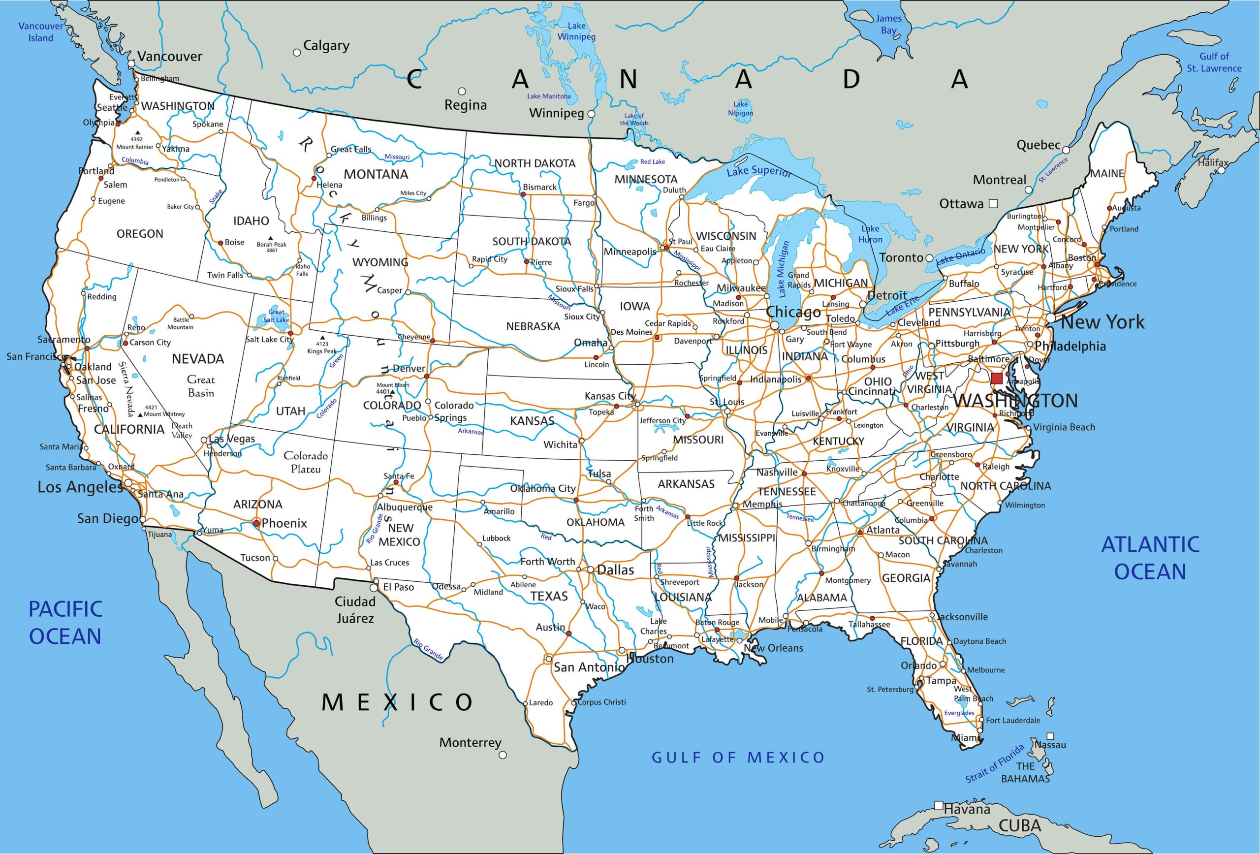
USA map with state borders and names
The United States of America occupies 9,518,900 km 2 of land and water bodies (according to other sources – 9,826,630 km 2 ). This number brings the United States to the third or fourth place in the ranking of the world’s largest countries. In terms of territory coverage, the state is second only to the Russian Federation, Canada and China.
USA on the world map is limited to such geographic features:
- south side – Mexico;
- northern – Canada;
- western – by the Pacific Ocean;
- eastern – by the Atlantic Ocean;
- southeast – the Gulf of Mexico.
The northern side of Alaska overlooks the Arctic Ocean, namely, the seas included in it: the Chukchi and Beaufort. Its eastern neighbor is Canada, and to the west across the Bering Strait is Russia. The southern and southwestern territory of Alaska is washed by the waters of the Pacific Ocean.
The state of Hawaii has no land neighbors; you need to sail across the Pacific Ocean to reach the islands.
Relief of the united states
The territory of the United States is heterogeneous in height above sea level, it is divided into several regions. Information about them is presented in the table:
| Region name | Where is | Description |
| Appalachian mountains | Eastern section stretching along the Atlantic coast from the northern side of Maine to the center of Alabama. | The length of the section is 1900 km, and the width is from 190 to 600 km. The average heights of the mountains are 1300-1600 m, the peak point is Mount Mitchell (2,037 km). |
| Atlantic lowlands | Occupies a section from New York to Florida. | Heights do not reach 100 m, width – 160-320 km. |
| Mexican lowland | Covers the territory from Florida to the Rio Grande (southern coast of the Gulf of Mexico). | The maximum width is 350 km, and the height is up to 150 m. Natural oil and gas reserves are concentrated here. |
| great plains | Pass through the center of the United States, covering 10 states, starting from North Dakota and down to Texas. | In fact, this is a foothill plateau with a height of 1500-1800 m in the west (the base of the Rocky Mountains) to 150 m at the eastern border with the Central Plains. The highest point in the region is Mount Harney Peak (2,207 km). |
| Cordillera | Western Stripe USA. | These are mountain ranges alternating with plateaus, lowlands and valleys. The peak point is Mount Elbert (4,399 km). |
Separately, it is worth highlighting Alaska. From west to east, the terrain is mostly mountainous. The north of the state lies in the Arctic lowlands, the center is the Yukon plateau.
Water bodies
There are more than 250 large lakes in the USA, almost 2 million artificial water bodies and more than 250 thousand rivers with a length of 5.6 million km. The runoff from these waterways enters the basins of three oceans – the Atlantic, Pacific and Arctic.
The pride of the United States is the Great Lakes, which is a complex of 5 large lakes and many medium and small reservoirs, rivers, straits. The area of the water system is 245.2 thousand km 2 .
The rivers of the country, occupying the first positions in the rating in terms of their length:
- Missouri – 3767 km;
- Mississippi – 3730 km;
- Yukon – 3190 km;
- Rio Grande – 3051 km;
- Arkansas – 2634 km.
The United States is washed by the Chukchi, Bering and Beaufort Seas.
Climate
The US map shows that the country contains regions with almost all existing types of climate:
- northern Alaska – arctic climate;
- the rest of Alaska is subarctic, coastal areas are oceanic;
- north and center – temperate type of climate;
- south – subtropics;
- Hawaii, south Florida – tropics.
The nature of the climate within one belt varies significantly, because it is influenced by relief and proximity to the ocean. The run-up in maximum temperatures is huge – from -62 ° C in Alaska to +56.7 ° C in Death Valley in California. In general, winters in the US are quite mild (except for Alaska), but air temperatures vary greatly from state to state. For example, in New York, the indicator is within +2 ° С, and in Miami – +22 ° С. In summer, in these settlements it is +25 ° С and +35 ° С, respectively.
There are many natural disasters in the US every year. In spring and summer, it’s time for a tornado, which is due to the mixing of air currents with a large temperature difference. Most often they occur in northern Texas, in Oklahoma, Tennessee. Hawaii and the southern regions overlooking the Gulf of Mexico often suffer from hurricanes. Also within the United States is the Pacific Volcanic Ring of Fire, on whose territory almost all the planet’s earthquakes occur.
Flora and fauna
The flora of the United States boasts of its diversity. The north of the country and Alaska are rich in coniferous forests and tundra. In the center of the United States, mixed forests grow with a large number of deciduous trees. The eastern part of the coast is pine, cedar and deciduous forests. In the west of America, deserts with an arid climate prevail, so bushes, cacti, succulents and palm trees grow here. In the humid climate of the Gulf of Mexico, subtropical and tropical representatives of the flora feel good.
The number of animals here is also very large, and their species depends on the region of the States. In the north of the country you can meet deer, bears, elks. Walruses and seals live in Alaska. The eastern part abounds with wolves, foxes, grizzly bears, badgers and more. The central part is dominated by animals that live in the taiga. Exotic flamingos, alligators and snakes are found off the coast of the Gulf of Mexico. The state is proud of its protected areas and is developing a conservation area, thanks to which there are so many unique animal species in the country.
Administrative divisions of the United States
The state is a federation of 50 states. Each of them is divided into districts. Washington, the capital of the United States, has a special status, because it is not listed as part of any state. This is the District of Columbia.
The United States also administers several islands that are not part of the states:
- Puerto Rico;
- Northern Mariana Islands;
- US Virgin Islands;
- Guam;
- American Samoa.
Major cities of the United States on the map
There are about 30 thousand cities on the US map. The largest are described below.
New York
Its borders overlook the Atlantic Ocean. The city itself is located in the southeast of the state of the same name. Area – 1223.3 km 2 . In winter, the temperature here is within -2 … + 5 ° С, and in summer – + 19 … + 28 ° С.
Los Angeles
A locality in the south of California, the main city of the district of the same name. It is located on the Pacific coast, and the Los Angeles River flows nearby. Area – 1299.01 km 2 . It is warm and sunny here all year round, snow falls very rarely.
Chicago
Located in northeastern Illinois, on the shores of Lake Michigan. On the territory of the settlement flow the rivers Chicago, Calumet. Area – 606.4 km 2 . Summer here is long, humid and warm with an average temperature of +23.3 ° C. Winter is cold, but does not last long, the thermometer at this time averages -4.6 ° C.
Houston
The largest city in the state of Texas, which is built on the coastal plain 50 km from the Gulf of Mexico. It rains very often here, so the village suffers from floods, as well as hurricanes. In spring and summer, the city is humid and hot, while winters are warm. The area of Houston is 1739.6 km 2 , of which 1658.7 km 2 falls on land .
Phoenix
Located in south-central Arizona. The city lies in the valley of the Salt River. The land area is 1340.7 km 2 . The climate of the city is desert, more than 80 days a year it is above 30 ° C, often the thermometer mark tends to + 39 … + 41 ° C. In winter, on average + 13 … + 15 ° C. It rains very rarely.
Philadelphia
The city is located in Pennsylvania on the coast of the Atlantic Ocean, and the Delaware River also flows through it. Area – 369.6 km 2 . It has a very mild but changeable winter with temperature fluctuations ranging from -15 to +20 ° C. Summers are long, humid and hot. Rainfall is plentiful all year round.
San Antonio
Located in the south of Texas, is the main city of Bear County. Land area – 1194 km 2 . Summer in the city is long, it is very hot and humid here. Winters are mild but cold at night. Floods often occur in San Antonio, and there is also a risk of tornadoes.
San Diego
The city is located in the state of California in the southwestern United States, near the border with Mexico. The area is 963.6 km2 . In the west, the city is washed by the Pacific Ocean. The average annual temperature of San Diego is within +18 ° C, and its sharp changes are not observed.
Dallas
Located in the northeast side of Texas, stands on the Trinity River. The total area of the city, including water resources, is 1000.3 km2 . In winter, the weather is very changeable, it can even be +30 ° С, but on average + 8 … + 10 ° С. In summer it is hot and stuffy, the thermometer mark often reaches +40 ° С.
San Jose
The city is located in Northern California among the hills of Silicon Valley. Area – 461.5 km 2 . The climate here is not dry, warm, strong winds do not happen here. The average temperature in summer is +25 ° С, in winter – +12 ° С.
Popular Reference Pages